Okay, I admit there's been something of a gap in my quest to run a minimum of 10K in each of the 50 states.
With nothing to report since 2013! Really?
But the drought is over, as I chalked up two states in two days during a recent silent film accompaniment road trip from New Hampshire to the Midwest.
The pair are Pennsylvania (#17, on Thursday, Dec. 10) and Kentucky (#18, on Friday, Dec. 11).
I'm not sure what's more amazing: that the December weather allowed for two long pleasant morning runs (in shorts!), or that I was actually able to complete them back-to-back without any injury or problem or really any soreness.
In fact, after each run I felt energized and calm for the rest of the day, a large part of which was filled with driving to the next city.
It reminded me of what it felt like when I was running long distances while a student in Glasgow: early morning runs through unfamiliar territory in cool but not cold weather, followed by a day of classes.
I had originally planned to try for a third state on this trip: Michigan on Saturday, Dec. 12. But this would have required driving two hours each way from where I was staying in Cleveland.
And by then, after spending most of the past three days behind the wheel, I didn't want to give up my one without driving, driving, driving.
Plus, I had completed two long runs in the prior two days. I felt fine, but I knew piling on another long one was courting trouble, and I had miles to go before I slept, if you know what I mean.
The Pennsylvania run was in the town of Coraopolis, a community on the south bank of the Ohio River just downstream from downtown Pittsburgh.
I mapped out what seemed like an easy route to follow, from my Motel 6 at the airport along a Thorn Run Road all the way to the river and downtown Coraopolis, then looping back by Main Street and Maple Street to Coraopolis Heights Road, which ran through a rural area all the way back to the hotel.

What I didn't count on was the incredibly steep drop down to the river. I expected a downgrade, but not the kind of descent I found myself making from the ridgeline above the Ohio River.
I must have lost at least 700 feet in a very short distance, finally bottoming out on "Fifth Avenue," which would not be mistaken for the New York City thoroughfare of the same name.
What goes down must come up, and I steeled myself (local industry reference!) for the right-hand turn on Main Street that would start taking me back up.

Although the small downtown was on a narrow flat plain along the river, the streets to the right of me literally took off up the slope at such a rate that second floor could have a door onto the sidewalk.
Turning onto Main Street, it seemed like it was straight up. Cobblestones were an interesting touch, and block by block I huffed my way back up the ridge.
I then ran into one of those frustrating moments where Google Maps doesn't exactly mirror reality. Main Street went up and up, and so did I, until it reached a dead end!
What? It was supposed to connect with Maple Street Extension, which I believed was the road running far below us. A postman confirmed this, and so I hustled along the edge of a large cemetery (the symbolism was not lost) going down to meet Maple Street Extension, and start the climb back up all over again.
The rest of the run went smoothly. I found myself feeling strong even as Coraopolis Heights Road stretched out before me through rolling countryside, with no sign of the airport for what seemed like a very long time.
End result: 6.9 miles in 1 hour, 31 minutes, for a pace of 13:12. I'll take it, especially considering those long upgrades.
The next morning found me in Covington, Kentucky, the urban community just across the Ohio River from downtown Cincinnati. I plotted a looping route that would take me across the Licking River and back, assuming the bridges had pedestrian crossings.
Weather was the same as the day before: cool and damp, with just the hint of a spritz of rain in the air.
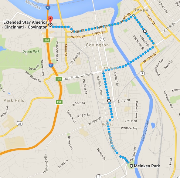
The first bridge did indeed accommodate pedestrians, and I soon found myself in a somewhat down-at-the-heel part of Newport, a place where the Pabst Blue Ribbon people still have a lock on all tavern promotional signs.
But still, the older housing stock had a lot of character, even if some of the brick buildings have been painted in alarming colors.
I then huffed my way back across another bridge and into Covington, where I went through some pretty spectacular neighborhoods, especially the Warren Avenue area.
After reacehing Meinken Park, I headed back, mostly along Madison Avenue almost the whole way back to the hotel.

End result: 8.0 miles in 1 hour, 45 minutes, for a pace of 13:07. Not bad considering what I'd run the day before.
So I felt pretty good after what for me were two long back-to-back runs.
Back in New Hampshire, the weather continues unseasonably mild even as I write this. So perhaps I might get one more nearby state before the year ends. We'll see.