Showing posts with label Jeff Rapsis. Show all posts

Saturday, November 2, 2019

The year of not getting physical

Welcome to the Aviation Museum of New Hampshire and Donut Distribution Facility!

I tend to throw myself into things.

So in taking a new job last year, some practices fell by the wayside. Like regular exercise.

Yes, I am executive director of the Aviation Museum of New Hampshire. And no, I have not been making time to exercise, work out, eat properly, or even sleep.

Thus did I get up at an annual fund-raising gala in September, and say this:

"In my first year as director of the Aviation Museum, I've gained so much. Specifically, I've gained 20 pounds from all the donuts and cookies that are so readily available around the place."

So right then and there, I vowed to return to the next year's gala 20 pounds lighter, or where I started when I took the job.

That was a month ago. Since then, I've actually made time to get out running with the dogs, and just yesterday added Wyoming to the list of states in which I've run 10K. (It's the 39th! Just 11 more to go.)

Other things need to happen, such as reducing the tendency to snack at night, which is totally psychological/behavioral and not driven by hunger.

But I'm on my way. And with 11 months to go, here's a to-do list:

• Get new running shoes. The current ones are shot, as I proved once again during yesterday's run in Wyoming.

• When cold weather arrives for good (any day now in my home area of New England), build in visits to the gym.

• Try to do something every day, even if it's minor.

• Get the remaining southern states (South Carolina, Georgia, Alabama, Mississippi and Louisiana) before September 2020 rolls around. (Actually, best time is Jan-March to avoid stifling heat and humidity later on.)

• And then get one more (probably Minnesota, easiest to get to cheaply) to bring the total up to 45.

• Run in 10 new places in my quest to run a minimum of 5K in all N.H. cities, towns, and unincorporated places. (Windsor, N.H., look out!)

• Get below 200 pounds. I don't honestly know what my weight was on September 24, 2019, when I made my vow, but it was up there. Ideally, I'd like to be well below 200 pounds consistently, which would be about 20 pounds below what I was carrying at the podium. :)

• When weather allows, get on bike. Ride to work when possible.

And then there's sleep. For many years, I found I could pull all-nighters and then get through the next day without too many problems.

No more. If I don't get adequate sleep, I can't function the next day and sometimes for several days afterwards. So, for the first time in my life, sleeping is actually part of the equation.

Will all this make a difference? Stay tuned...

Saturday, October 28, 2017

A tale of one city, and three towns: Berlin (#147), Alstead (#148), Langdon (#149), and Unity (#150) — plus a rare supernova over Acworth, N.H.

In the past two weeks, I've added four more communities to the quest to run at least 5K in every New Hampshire municipality. (And unincorporated places, too!)

Here's a round-up of latest adventures.


• Friday, Oct. 20: a swing through the state's northern reaches and really mild weather for October provided a chance to bag Berlin (#147), so I took it.

Hoped to combine it with the adjacent town of Milan, but time didn't allow. So I measured off 1.6 miles from the Berlin/Gorham line, which put my start right in the middle of Berlin's modest downtown.

Out and back under the bright sun, windy conditions. Elapsed time: 37 minutes.

Never been to Berlin but know the story: ex-paper mill town that's now reinventing itself as an outdoor recreation hub.

The city's most lasting claim to fame? It's the birthplace in 1907 of Earl Silas Tupper, inventor of Tupperware.

Running through the streets in late October, even on a warm day, you get the unmistakable vibe of a city hunkering down for the long winter ahead.

Trivia: Berlin is one of New Hampshire's 13 cities, which are different from the state's 221 towns due to the way their municipal government is organized.

I just checked, and I still have one more city to go: Laconia, look out!


• Saturday, Oct. 21: silent film show in Vermont took me through western New Hampshire, so made use of another warm afternoon to claim Alstead (#148) and Langdon (#149).

Parked at shuttered Mascoma Bank branch (drive-thru now occupied by wasps) conveniently located on Alstead/Langdon border.

Once covered this area for local papers, the Claremont Eagle-Times and the Keene Sentinel, so the roads of these small and quiet and remote towns are still familiar.

First into Alstead, past modest homes built in an era of expectations that the town would grow much larger (but never did), then over the bridge across the Cold River, past the library and the store, and then up Route 123 past the Vilas School to turn-around point, just past the junction of Route 123A to Acworth.

Trivia: the town is not pronounced "Awl"-stead. It's "Al" stead. Even so, it's still obvious you're from away.

Upon reaching the bank, checking time at 44 minutes. Slow!

Hey: not only two towns, but two counties! Alstead is in Cheshire County, Langdon is in Sullivan County.

Now the other way, into Langdon, a rural upland town that's home to Fall Mountain Regional High School but still one of the smallest communities in these parts.

I wrote a lengthy profile of Langdon back in 1990 for the Sentinel, and at the time the town still hadn't recovered from depopulation that began in the 19th century and affected many upland towns.

Consider: the town's population peaked in 1830 at 676. Then people started leaving Langdon, and didn't stop until a century later, in 1930, when the census bottomed out at 267.

Things have been recovering since then, and by 1990 had reached 580—nice, but still below the Langdon's 1830 heyday.

Well, here's an update. I'm pleased to report that the U.S. Census of 2010 reported 688 residents. So, 180 years later, Langdon is back in growth mode.

That still didn't make for crowded roads. I jogged down Route 123, then up Cheshire Turnpike Road, encountering few vehicles and no people.

Due to Route 123 sliding across the border into Walpole for a stretch, I had to account for 2/10th of a mile that wasn't technically in Langdon.

But this put me further up Cheshire Turnpike Road, which was one long include up a ridge overlooking the rural valley below Fall Mountain.

With sun lighting up the countryside—stone walls and foliage and open fields laid out below rich blue skies—it was one of those days you're glad to be outside, and you remember.

Back at the car, time was another 44 minutes. So much for speed.

• Friday, Oct. 27: silent film show in Canaan, N.H. and another warm afternoon allowed me to bag Unity, N.H. (#150), another rural town in the state's western reaches.

Wanted to get adjacent Acworth as well, but alas, lack of time (and leaving my wallet at the office in Manchester) limited the day's activities.

However, coming through Acworth, I couldn't help but stop to photograph the town's immense hilltop 1821 meetinghouse, lit up by the afternoon sun.


In doing so, I accidentally activated my cell phone's "selfie" lens, which I haven't been using because images are blurred by an air bubble in the phone's protective covering.

But all of that, including triggering the camera directly into the sun, produced this remarkable image of a supernova over Acworth, N.H.:


The run along North Shore Road in Unity was marred by the realization that I'd left my wallet back in my office in Manchester, which would complicate the rest of the day.

But off I went, with part of the route on a dirt road. Another quiet afternoon in rural New Hampshire, slightly cooler than previous runs but still nice.

Out and back, through the rolling countryside, total 43 minutes.

And that makes it 150 towns, which I was the short-term goal for this year. Yay!

A few nice weekends might allow me to push past that. We'll see.

For now, the immediate challenge is an upcoming chance to add not one but two states to the trophy case in my quest to run at least 10K in all 50 states. Stay tuned!

Sunday, October 8, 2017

Claiming Plainfield, N.H. (#146) and running amid the pumpkin people

Where I started, and also where I finished.

Pretty nice fall day for a run: a bit warm but overcast, with a light rain falling.

But whatever the weather, I sure picked the right time of year to pick off Plainfield, N.H., making it Town #146 in my quest to run a minimum of 10K in every town, city, or unincorporated place in New Hampshire.

I didn't know this, but turns out October is when the Pumpkin People emerge in Plainfield. Not content with mere Jack-O-Lanterns, it's an annual tradition for town residents to create elaborate roadside tableaux featuring everyone's favorite seasonal gourd.

How elaborate? How about this re-enactment a scene from the movie 'Titanic' (1997), which I passed on Stage Road?


How about something more topical, such as this eclipse-watching pumpkin astronomer?


Driving too fast? Meet the Pumpkin-As-Officer-Running-Radar, posted on a fast stretch of Route 12A north of town?


Officer, why are you smiling at me like that?


And how about this whole pumpkin family, stepping out?


So altogether, this made for a pretty entertaining run. And when there weren't pumpkin people, other objects of interest filled the gaps:


Want something more Halloween-like. How about the town's picturesque village cemetery, which seems to have plenty of open space...


And yes, before I forget: I did go for a run: a nice out-and-back on Route 12A, which for much of its journey through Plainfield is a narrow winding highway with no shoulder to speak of.

But about a mile-and-a-half before Plainfield Village, the road suddenly broadens to a whole new and more generous set of specs, with great visibility and a wide breakdown lane.

The post office in town was exactly 1.6 miles (by my odometer) from this point, so that was my route: out and back, a total of 3.2 miles.

As a bonus, the widened highway started at a crest in the road, just before a long series of smooth and gentle downgrades into the town.

Where Route 12A widens, facing south towards Plainfield Village.

So it was mostly gentle uphill to the turn-around point, then a nice forgiving downhill all the way back.

If any of the landscapes seem familiar, it's because Plainfield was for many years home to renowned American artist and illustrator Maxfield Parrish.

Although Parrish passed on in 1966, he's still a big man around town. In the Village, I ran past the old town hall, which boasts a set of scenery designed and painted by Parrish back in 1916, and it was open for weekend visitor scrutiny. (I demurred, not wanting to drip on the historic Parrish set pieces.)

Back at the post office, a bulletin board of real estate notices included what seemed to be a major one: for the first time in decades, the actual 45-acre Maxfield Parrish estate, known as "The Oaks," was up for sale!


Wow! If you've got a spare $1.3 million, it could be yours. It all sounds pretty nice, although you might end up being asked to paint some new scenery for the Town Hall.

And what about my time? I'll call it 37 minutes even to run 3.2 miles, good enough for claiming the Connecticut River Valley town of Plainfield and filling in a gaping hole in my office map, which I did this morning.


What's next? Now that I'm back in the local running groove, I'd like to pick up a few more towns before the weather turns. Maybe get to #150—we'll see.

Stay tuned!

Thursday, May 25, 2017

Bike routes, plus some notes about Summer 2017

This season I've had it in my mind to do what I call the "New Boston loop" before Memorial Day weekend.

Well, I'll be on the road for Memorial Day weekend, so I took advantage of a warm late afternoon yesterday and did it.

The apex of the loop is "downtown" New Boston, a small crossroads with Dodge's Store as a landmark:

Click to enlarge.

The route out is rolling countryside with many ups and downs, but none really epic.

Going back, it's a different story. Check out the hill, circled in the grade profile at left:


That's the big climb up one side of the Uncanoonuc Mountains in Goffstown, of which Wallace Road skirts the eastern slopes.

It's not bad, but loooong, and climaxed by a couple short but very steep pitches before cresting the high point at Shirley Hill Road.

Then it's a long glide back to home base. Total distance: 28.3 miles. Time: about 2.5 hours, but I didn't really time it closely.

The other looping bike route I've been doing since the weather changed is a much more level loop that takes me south along one side of the Merrimack River to my hometown of Nashua, then back up on the other side.

Here's the route down, which runs through countryside that's still quite rural, with a lot of land in active farming:


And here's the route back, which is mostly through suburbia:


Total distance on this loop is 31.5 miles: longer than the New Boston circuit, but because it's more level it usually takes no more than 2:15 to complete.

One thing I like about this route: both directions take you near the enormous Anheuser Busch brewery in Merrimack, N.H. You can tell which direction the wind is blowing when you encounter the aromatic cooked malt fragrance that comes from the place.

What's next? Before I start longer rides out to the hilly west, or east to the coast, I need more time closer to home.

So one loop I will try is to go counter-clockwise completely around the city of Manchester.

Using the Auburn Village School as the apex, the first part of the route would look like this:


Then back, the lack of bridges over the Merrimack to the north means I'd have to come through Manchester's North End to get home:


So the total mileage is 33.3, a slight increase and a new route besides. I'll try that one when I'm back in town after Memorial Day weekend.

Longer term, I'd like to bike at least once to the coast (for fried clams at Ceal's Clam Stand in Seabrook, N.H.)and then all the way back. Long ride of about 95 miles.

Here's my preferred route out:


Coming back is a challenge, with a steep climb from Candia into Hooksett on Route 27, then a descent into the Merrimack Valley:

This route map has me heading in the wrong direction. :)

And two routes to the west: one a loop out to Harrisville Pond (for a mid-day) swim and then back, about 90 miles through some very hilly terrain; the other a long one-way to Bellows Falls, Vt.

Injury-free right now but just overworked with not enough time to push myself. Not running too much but will try capturing a few towns this season.

Updates as they happen.

Tuesday, October 18, 2016

Bagging Croydon (#144) and Granthan (#145)
in the quest to run 5K in all N.H. locations

Where I didn't want to leave my car.

If we ever have to do without cars, I know how long it would take to get from Croydon to Grantham, N.H.

I ran a "back-to-back" in those two towns this past Saturday, making them #144 and #145 in my quest to run a minimum of 5K in every city, town, and unincorporated place in New Hampshire.

And unlike a lot of these runs, this one worked out to be between the two actual villages rather than just out in the middle of nowhere, although there was certainly enough of that. Read on!

The date: Saturday, Oct. 15. Due in Brandon, Vt. that evening for a performance, my original plan was to veer further north and knock off two more-distance communities: Wentworth and Warren.

But a late start and then heavy traffic on Interstate 93 heading north prompted me to change plans before the I-93/I-89 split.

I didn't really have a Plan B, but realized en route that Croydon and Grantham were two towns I needed, and were just off I-89 on the way to Vermont.

So up I went, taking Exit 13 in Grantham and following Route 10 south towards Croydon.

Good old Route 10, which wanders through the western part of the Granite State from the Mass. line all the way up to Hanover and Dartmouth College.

I actually once wrote a travelogue about Route 10 for New Hampshire Magazine some time ago. It doesn't seem to be online anywhere—perhaps I'll fish it out of the archives and post it later.

Travelogue or not, here I was again on Route 10 as it wound its way along the shallow valley of the North Branch of the Sugar River, which was just beginning its long journey to the Connecticut River.

My usual method of a "back-to-back" is to find the boundary between two towns, then pace off 1.6 miles in each direction, noting the turn-around point at each end.

I then return to the border and head out in one direction as far as the turn-around point, then head back and cross the border in the other direction.

At the second turn-around point, I then head back the start, which is now the finish line.

As long as I've done the math right, that's a minimum of 3.2 miles in each community. And that exceeds my minimum distance of 5K, which is 3.1 miles.

One reason this works so well is that for some reason, New Hampshire communities are very good about marking the town lines.

Maybe it's due to road maintenance obligations. Maybe just a turf thing. But in New Hampshire, roads in and out of even the smallest, most remote towns invariably sport flashy green border markers.

The roads themselves may be crumbling to pieces, but the signs always seem look brand new.

Look at the size of that breakdown lane!

In this case, Route 10 wasn't falling to pieces. On the contrary: it was clean and dark and newly paved with a smooth surface and a gentle crown.

The speed limit was as high as 55 m.p.h. on long "straightaways" (as we call them), but a generous breakdown lane would keep a runner from feeling any danger.

The Grantham/Croydon line happened to be right in the middle of one of these straightaways, out in the open for all to see.

One disadvantage to this to this: there was no convenient place to stow my car. Not that anything would happen here, other than a bear coming by to ransack the vehicle.

I just don't like leaving it out in the open while I'm off jogging around.

I then hopped back in to measure off 1.6 miles into Croydon to find my turn-around point. To my surprise, the village of Croydon came up quite quickly: the historical society, the church, the school, the Coniston General Store.

That last one is a nod to the 1906 novel "Coniston" by New Hampshire author Winston Churchill, not be confused with the British politician of the same name.

"Coniston," a best-seller, was an historical tale set in the world of 19th century New Hampshire politics. Locations included the fictional town of Coniston, which was a stand-in for Croydon.

And the turnaround coincided exactly with Pat Sawyer Memorial Park, completely deserted but with a nice parking area.

And right across the highway: Milepost 60.0. So I immediately decided to base myself here: 1.6 miles from the town line. I would run back up the highway, over the town line into Grantham, and then as far as Milepost 63.2.

I'd then turn around and retrace my steps. Presto! Two towns, and a little more than 5K in each.

And so it came to pass. The afternoon was warm for October: temps in the high 50s, but with almost no wind.

High clouds were moving in from the south, filtering out the sun and muting the fall colors all around me. A pretty good day to be out for a run.

I'll meet you at the old barn. You know—the old barn!

I started at 1:32 p.m., heading north, accompanied mostly by the sound of my own feet on the pavement, the occasional passing vehicle, and occasional bursts of rifle fire from the woods.

One virtue of Route 10 following the valley of the North Branch of the Sugar River is that even though we were high in the hills, the course was almost completely flat!

The only grade at all was a short bump up into the town of Grantham proper, at the far end of my route.

The exact turn-around spot of Milepost 63.2 was at Grantham's Dunbar Library, across from the United Methodist Church. Village to village!

And I couldn't help but think I had covered the distance between both towns on foot in a way that must have been much more common say, a hundred years ago.

In case anyone wants to know: people can still do it, if they have to. I did, anyway.

I felt strong pretty much the whole way. No foot pains, no issues at all.

As I strode through Croydon on final approach, I was surprised to find Pat Sawyer Memorial Park now being used by three men at the lone basketball net, shooting hoop.

They left me alone, and I left them alone. But if they were curious about the guy in the orange shirt and black shorts running through their town last Saturday—well, he made it to Grantham and back in exactly 1 hour and 20 minutes.

The distance was 6.4 miles, meaning a pace of 12:30. That's somewhat better than what I've logged lately, probably because of the flatness of the course and the pleasantness of the weather.

Next up: Running in another state this week. More later!

Friday, June 17, 2016

Bagging Delaware (#24) on a soggy day
and notes about other recent adventures

My all-weather map of Delaware. Note state's name spelled wrong.

Okay, it's been awhile so figured time for an update.

Amazing but true: I've kept up the one-per-month pace in my quest to run a minimum of 10K in all 50 states.

Just yesterday (Thursday, June 16), it was Delaware. In May, it was Nevada. In April, Massachusetts. The last day of March found me in unseasonably mild rural Rhode Island, while February brought me to Central City, Nebraska, which I discovered is anything but central.

So I'm now up to a total of 24, and running out of close-by states, which means it'll be more challenging to keep the once-a-month pace going.

The only states I have within driving distance are Maine and, sort of, New Jersey.

The remainder will involve at least some kind of trip away from home base to accomplish. Some can be done in one day if I find a cheap air fare.

But right now, I don't have any firm plans until when I go out to California November. That's when I might try to get either Oregon or Washington. Or both. :)

A planned visit to Sioux City, Iowa next February will give me a chance to bag that state and maybe a couple of others in the upper Midwest: South Dakota and Minnesota.

Among states in the "day-trip" category are a stretch in the deep south: South Carolina, Georgia, Tennessee Alabama, Mississippi and Louisiana. With JetBlue and Southwest out of Boston, they're all doable.

Same thing with a few in the Midwest: Indiana, Michigan, and Wisconsin.

Well, if I can somehow keep up a pace of one state per month, that means I'll be finished by...July 2018!
That's not allowing for recovery from knee surgery I'm sure I'll need at some point.

And as for Delaware: Dover is hands-down the flattest place I've ever run in. For the entire route, the biggest gains (or losse) in altitude were when I hopped on and off a curb!

I'll give the place high marks for sidewalks, though. Of the entire 6.6-mile course, which included some stretches of road far out in the suburbs, only one short section was without some kind of pedestrian way.

Lots of bike paths as well. Wish my own area of Manchester, N.H. and its surrounding suburbs could enjoy amenities like this.

In other news:

• Summited Mount Moosilauke with a small party on Saturday, June 11. Didn't add to my total of 4,000-footers, which still stands at 31. Still, it was enough to get me back on the trail.

A busy calendar, alas, means there aren't too many opportunities in the near future to conquer any more of the 48 peaks on the list.

A new wrinkle is our youngest dog, Inca. She likes to get out and did well on Mount Moosilauke, save for not appreciating rain on the way down.

For her, Mount Moosilauke was #6, so it's time to get moving if she's going to have a chance to complete the whole roster.

Alas, our older dog, Zahnna, is now too infirm to haul herself up (and down) a White Mountain summit. As a 13-year-old German Shepherd, she now has trouble with household stairs, so her total of peaks will have to stand at 31—the same as me.

• Haven't yet run in any official road races this year. Again, mostly a function of time and organization. I have these fantasies of getting up early on the weekends and hauling myself out to New Hampshire communities I've yet to run in. Ha!

But will make it a priority to make some progress in this area. Same with longer bike rides.

Sunday, December 20, 2015

Adding Pennsylvania (#17) and Kentucky (#18)

Geez, look at those elevation lines to the south of downtown Coraopolis.

Okay, I admit there's been something of a gap in my quest to run a minimum of 10K in each of the 50 states.

With nothing to report since 2013! Really?

But the drought is over, as I chalked up two states in two days during a recent silent film accompaniment road trip from New Hampshire to the Midwest.

The pair are Pennsylvania (#17, on Thursday, Dec. 10) and Kentucky (#18, on Friday, Dec. 11).

I'm not sure what's more amazing: that the December weather allowed for two long pleasant morning runs (in shorts!), or that I was actually able to complete them back-to-back without any injury or problem or really any soreness.

In fact, after each run I felt energized and calm for the rest of the day, a large part of which was filled with driving to the next city.

It reminded me of what it felt like when I was running long distances while a student in Glasgow: early morning runs through unfamiliar territory in cool but not cold weather, followed by a day of classes.

I had originally planned to try for a third state on this trip: Michigan on Saturday, Dec. 12. But this would have required driving two hours each way from where I was staying in Cleveland.

And by then, after spending most of the past three days behind the wheel, I didn't want to give up my one without driving, driving, driving.

Plus, I had completed two long runs in the prior two days. I felt fine, but I knew piling on another long one was courting trouble, and I had miles to go before I slept, if you know what I mean.

The Pennsylvania run was in the town of Coraopolis, a community on the south bank of the Ohio River just downstream from downtown Pittsburgh.

I mapped out what seemed like an easy route to follow, from my Motel 6 at the airport along a Thorn Run Road all the way to the river and downtown Coraopolis, then looping back by Main Street and Maple Street to Coraopolis Heights Road, which ran through a rural area all the way back to the hotel.

Here's Part 1 of the Pennsylvania run, using Dairy Queen as a landmark.

What I didn't count on was the incredibly steep drop down to the river. I expected a downgrade, but not the kind of descent I found myself making from the ridgeline above the Ohio River.

I must have lost at least 700 feet in a very short distance, finally bottoming out on "Fifth Avenue," which would not be mistaken for the New York City thoroughfare of the same name.

What goes down must come up, and I steeled myself (local industry reference!) for the right-hand turn on Main Street that would start taking me back up.

Here's Part 2 of the Pennsylvania run.

Although the small downtown was on a narrow flat plain along the river, the streets to the right of me literally took off up the slope at such a rate that second floor could have a door onto the sidewalk.

Turning onto Main Street, it seemed like it was straight up. Cobblestones were an interesting touch, and block by block I huffed my way back up the ridge.

I then ran into one of those frustrating moments where Google Maps doesn't exactly mirror reality. Main Street went up and up, and so did I, until it reached a dead end!

What? It was supposed to connect with Maple Street Extension, which I believed was the road running far below us. A postman confirmed this, and so I hustled along the edge of a large cemetery (the symbolism was not lost) going down to meet Maple Street Extension, and start the climb back up all over again.

The rest of the run went smoothly. I found myself feeling strong even as Coraopolis Heights Road stretched out before me through rolling countryside, with no sign of the airport for what seemed like a very long time.

End result: 6.9 miles in 1 hour, 31 minutes, for a pace of 13:12. I'll take it, especially considering those long upgrades.

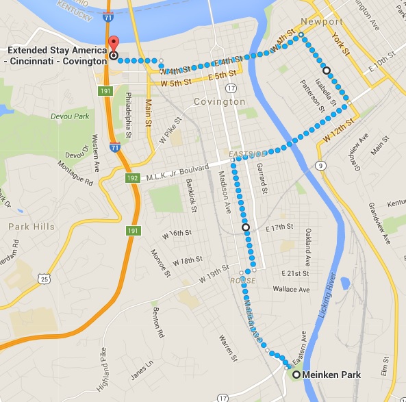
The next morning found me in Covington, Kentucky, the urban community just across the Ohio River from downtown Cincinnati. I plotted a looping route that would take me across the Licking River and back, assuming the bridges had pedestrian crossings.

Weather was the same as the day before: cool and damp, with just the hint of a spritz of rain in the air.

The route first took me across the Licking River into Newport, then back into Covington.

The first bridge did indeed accommodate pedestrians, and I soon found myself in a somewhat down-at-the-heel part of Newport, a place where the Pabst Blue Ribbon people still have a lock on all tavern promotional signs.

But still, the older housing stock had a lot of character, even if some of the brick buildings have been painted in alarming colors.

I then huffed my way back across another bridge and into Covington, where I went through some pretty spectacular neighborhoods, especially the Warren Avenue area.

After reacehing Meinken Park, I headed back, mostly along Madison Avenue almost the whole way back to the hotel.

Taking the direct route back to the hotel, for a total of 8 miles.

End result: 8.0 miles in 1 hour, 45 minutes, for a pace of 13:07. Not bad considering what I'd run the day before.

So I felt pretty good after what for me were two long back-to-back runs.

Back in New Hampshire, the weather continues unseasonably mild even as I write this. So perhaps I might get one more nearby state before the year ends. We'll see.

Sunday, December 6, 2015

Bagging two more New Hampshire towns:
Shelburne (#142) and Gorham (#143)

My turn-around point in Shelburne was this spot, exactly 1.6 miles from where I parked the car at the 27.0 mile marker. Late afternoon in December = looooong shadows.

I never thought I'd go running north of Mount Washington in December—in shorts!

But a spell of unseasonably mild weather in our part of the world allowed me to bag two towns "north of the notches," as they say: rural Shelburne and comparatively cosmopolitan Gorham. And I didn't have to bundle up.

The date: Saturday, Dec. 5. The occasion: on my way to an annual silent film screening in the even-further north community of Dixfield, Maine. The goal: to run a minimum of 5K in at least a couple of towns that I doubt will ever hold an official road race.

I don't often get to run in towns this far north. But in planning this gig, I figured that on my way it might be possible to fit in a run among the enormous snowbanks usually in place by now.

Well, Mother Nature had other plans. The higher summits of the surrounding White Mountains are indeed white, but winter hasn't quite reached the valleys just.

Thus I found myself pulling off Route 2 at the Gorham / Shelburne line onto a grassy patch that made for a perfect parking spot.


As it became clear that the weather would be unseasonably nice, I actually had plans to bag four towns. Before Gorham / Shelburne, I had hoped to do a similar two-town run in Jefferson and Randolph, through which Route 2 also runs.

But coming up through Franconia Notch, I noticed a light coating of snow on the shoulder. And heading further through Twin Mountain, I watched as the temperature dropped below 40 degrees. Anything lower requires extra gear, which I didn't bring.

So I wasn't sure about the Jefferson / Randolph stretch, and then ultimately bagged it because that section of the road is narrow, with very little shoulder, and has a lot of steep ups and downs. That, plus the slushy roadside snow and the at-times heavy traffic, made me push on to Gorham / Shelburne.

It turned out to be the right decision. They're at a lower elevation, so the temp had recovered to the mid-forties by the time I pulled in. Plus, the road follows the Androscoggin River, which at this point flows along a flat stretch of valley. And Route 2 is in pretty good shape in these parts, too.


After measuring off 1.6 miles in each direction, I returned to the town line and began the Shelburne stretch at 3:25 p.m.

A long straightaway and then some up-and-down curves took me through some of the dense groves of birch trees for which Shelburne is known. Fun fact: Shelburne's population was 480 in 1859, but only 372 now. So it's one of those upcountry towns that went into decline after the Civil War and still haven't recovered.

I came back to the car at 4:03 p.m. meaning 38 minutes to do 3.2 miles. Nothing to brag about there.

Heading into Gorham for the second part of the run, it was starting to get dark in the valley even though some of the peaks high above us were still catching the light. The wind picked up a bit, but running in shorts still felt fine.


Talk about scenery! The rocky, snow-capped summit of Mount Madison, the nearest Presidential Range peak and rising high above us to the south, looked more like the Matterhorn than it deserved to.

After the rural emptiness of Shelburne, the town center of Gorham seemed like Midtown Manhattan. Stores, restaurants—even sidewalks! (The town's population is about 3,000.)

After my turn-around point, I was headed east-bound, meaning I could better see the day's fading light still kissing the upper reaches of ridges hemming us in. The snow had probably melted a bit and was now refreezing, making the higher spots look like they were lightly dusted with powdered sugar. (Can you tell I was hungry?)

Funny: in Gorham I passed signed promoting the town's 5K run on Thanksgiving. Ooops, missed it!

Reached the car at 4:43 p.m., meaning about 40 minutes for the final 3.2 miles. By then it was completely dark, but the temperature had dropped just a bit: to 41 degrees.

And so I had just enough time to drive up the street to the town's Subway (housed in a former bank branch office), where I changed into my performing clothes and got a sandwich.

Next up: this coming week I'm on a road trip to Ohio and Toronto, Canada, and so have an opportunity to claim as many as three new states in my quest to run at least 10K in all 50.

Stay tuned!

Wednesday, November 4, 2015

Another month, another half-marathon!

In the least unflattering photo of several taken during the race, I'm about to cross the finish line.

It was a few days ago now. But this is to note that I ran in and finished the half-marathon version of this year's Manchester (N.H.) City Marathon.

The race, held Sunday, Nov. 1, 2015, attracted 344 entrants for the half-marathon of 13.1 miles, vs. about 200 for the full 26.2-mile marathon.

In a race this long, most of my effort goes into carefully pacing myself so as not to become hobbled prior to finishing.

The Manchester course contains quite a few ups and downs, and I have to be very careful not to overdo it on the downs, as this is where bodily stress accumulates fast.

Also, there's a short section of trail running in Livingston Park, which is beautiful to look at, but can trigger problems as my feet hit the rocky surface. So I take it especially slow during that stretch.

But I did manage to keep stride the whole time, not stopping once. I finished at 2 hours, 43 minutes, and 41 seconds, for an overall pace of 12:29 per mile.

That was good enough for 323rd place out of 344 finishers, which is a victory for me in the sense that avoided coming in dead last.

It was my slowest half-marathon yet, but the silver lining is that afterwards I felt only minimal soreness in my feet, ankles, and legs.

After two half-marathons in the last month, could I be building up my ability to run longer distances?

And could that possibly lead to trying to run a full 26.2-mile marathon one of these days?

Time will tell.

Next up: an attempt to add Nevada to the list of states in which I've run a minimum of 10K.

I was hoping October would allow me to add Vermont, but a flat tire and other misadventures during a swing through the Green Mountain State prevented that from happening.

And also, I find I've been missing races in N.H. towns that I could still use.

Just this past month, 5K races were run in Walpole and Holderness, two towns I've wanted to get for a long time. Grrrrrr.

I used to rely on www.coolrunning.com for race listings, but a recent "upgrade" to the site has rendered the "upcoming events" much harder to use and a lot less comprehensive, apparently.

However, the site still carries results of races, which is how I found out about the ones I missed.

So I'll have to reverse-engineer the process, reviewing results from this year and then searching to see if the race will be run next year.

No one said this was supposed to be easy. But sometimes it's harder to find out about races than actually run in them!

Tuesday, October 20, 2015

Bagging two Connecticut River valley towns:
Orford (#141) and Lyme (#142), plus a flat tire

A swing through the Connecticut River Valley this past weekend led to the latest trophies in my quest to run at least 5K in every New Hampshire city, town, or unincorporated place.

On Saturday, Oct. 17, I bagged the small rural communities of Orford and Lyme, making them #141 and #142, respectively.

It's a beautiful part of the state, and the run took place along a lonely stretch of Route 10 that saw very little traffic.

To get there, I came up I-91 from White River Junction, Vt., crossing back over to New Hampshire via the Samuel Morey Memorial Bridge. It's a classic green steel arch span built in 1937-38 after the great floods of 1936 washed away its wooden predecessor.

The bridge was recently rehabbed and looks brand new. Here's a photo from the Valley News, a daily paper that circulates in the area:

I assume unicycles aren't commonly seen around here.

My aim was the Orford/Lyme town line, from which I'd measure off 1.6 miles in either direction. Conveniently, the spot is served by a school bus turn-around, allowing for easy parking.

Here's a view north on Route 10 into Orford.

And here's a view showing the other direction, south into Lyme.

A cold front was pushing its way in from the west, making for cool and changeable conditions. Temps were in the mid-40s, with occasional breaks of sun balancing off chilly winds. Still shorts weather, but just barely.

I started at 1:20 p.m., heading north into Orford, where the highway runs through the relatively rich farmland (for New Hampshire, anyway) of the Upper Connecticut River Valley. My route took me right past a large and active dairying operation, which on the wind smelled like wet leaves being rubbed in my face.

Looking south from the Orford turn-around point.

One big up-and-down took me to my first turn-around point: Tree Farm Road, exactly 1.6 miles from the town line. I touched it and then headed back, ready to smell more "wet leaves."

Traffic was so light, and the shoulder was often so crumbled, that I found myself gravitating into the travel lanes along the long straight-aways, which offered a better surface. Yes, Route 10 is a major state highway, but often the only sound I could hear was of my shoes scuffing the pavement.

While passing into Lyme, I checked the car's dashboard clock: 2 p.m. exactly, or 40 minutes to do maybe 3.4 miles. Pretty slow!

The route into Lyme consisted of a pretty significant downhill stretch followed by a flat road, then a pronounced up-and-down dip as the highway negotiated a swale.

It was this spot where I encountered a deer leaping across the highway in broad daylight as I was measuring off the distance. But all was now quiet as I ran through this area.

Turn-around point was this "Bear Left" sign, which I touched and then turned around.

Facing north, you can see the dip in Route 10 in the distance.

The way back included a nice slog back upthe grade I'd descended earlier. But everything held together as I reached the starting point at 2:40 p.m.—so 40 minutes for the Lyme leg, exactly the same as Orford.

So that allows me to color in two good-sized adjacent communities on my big New Hampshire map: Orford as #141 and Lyme as #142. Even though the weather is changing, I hope to keep the momentum going and bag a few more before the oncoming winter buries us.

Alas, I returned to find my rear driver's side tire nearly flat. The car was still driveable, though, so I rolled slowly until the first air pump, which I found across the river in Fairlee, Vt.

That was enough to get me to Rutland, Vt., where the tire went completely flat. Swapping it out for the "donut" spare required me to unload all my musical gear into the parking lot of a Days Inn, leading to the discovery that my Subaru Forester is missing its jack!

But I was able to borrow one from some leaf-peepers from New Jersey, which allowed me to complete the swap and make it to my silent film gig that night in Brandon, Vt.

The car has All Wheel Drive, so I really didn't want to drive any real distance without matching tires. Luckily, I had arranged to stay in Rutland that might because of a show the next day in Charlestown, N.H.

So on Sunday morning, I was relieved to find that a Tire Warehouse place in Rutland was open. And it took them just a few minutes to find a nice piece of heavy gauge metal wire than had somehow pierced the tire. It was easily patched for $25, saving me the unplanned cost of a full set of new tires.

Alas, this adventure got in the way of plans to run 10K in Rutland that morning, which would have added Vermont to the list of states that I've run in.

But Vermont is close by, and also it was actually snowing on Sunday morning. So both factors figured into the decision to hold off.

On the upside, the morning overcast blew out to reveal an autumn riot of vivid colors in the landscape: blazing foliage on surrounding slopes, topped with brilliant white snow on a few higher peaks, all under a bright blue sky. It was like one of those idealized postcards of New England, but it was real.

The brilliant sun also lit up Jones' Bakery, a place I'd always wondered about. I'd never been in Rutland when it was open, but that's because it's only open on mornings.


A visit found a real throw-back: a local bakery in operation for 93 years, I was told, with everything made from scratch.

So I celebrated my new tire patch with a couple of real donuts: a plain and their version of a Boston Creme. Both were just fantastic, prompting me to get a dozen to bring to work the next day.

Next big adventure: the Manchester (N.H.) Marathon on Sunday, Nov. 1. I'm running the half-sized version. Lots of ups and downs in this one, but still hoping to beat my time of 2:39:38 earlier this month.