Switzerland's 'Lake Macun' plateau from an overlooking ridge.
I've been hoping to post notes of a day-long solo hike high up above treeline in the Swiss Alps, a highlight of this summer's visit to Switzerland.
Of special interest: way above treeline, I lost the trail, nearly went down the wrong valley, and had to embark on a high-altitude bushwhack that was unnerving if ultimately successful.
Now it's Labor Day weekend, so better get
something up before it all fades. So here goes.
Please note that many of the photos are of scenery on a grand scale. I encourage you to click on the images and view them as large as possible.
Wednesday, July 23: Dawn at Zuoz, a small town in the postcard-perfect Engadine Valley of southeast Switzerland. The weather? Rain all week—tough luck for an area that boasts more days of sunshine per year than any other part of the nation.
But this morning, the sky is blue. Sunshine kisses the bare peaks high above. Updated forecast? Broken clouds, with rain moving back in by mid-afternoon.
So it's a go. I throw on my pack and head out, descending cobblestone streets to the small town's train station. But then I realize I don't have my raincoat.
Up and back, and already I'm feeling winded. How do I expect to make it to 9,600 feet? Same as always: one step at a time.
Today's journey is a through-hike up to an area called the Lake Macun plateau. An unusual basin above treeline, it's home to a network of high-altitude ponds and tarns fed by snows and run-off from surrounding peaks.
The trail through it—starting in Lavin and ending in Zernez—is 23 kilometers, or about 14 miles, and includes an altitude gain of about 5,000 feet along the way. A guidebook's one-word description: "Challenging."
A chart showing the altitude profile of the trail. Like everything else, I did it backwards, from right to left.
The red train of the Rhaetische Bahn (a private narrow gauge rail line that serves this part of the country) pulls into Zuoz right on time: 7:27 a.m.
And off we go, rolling across the verdant valley floor. Craggy peaks tower above us on either side, their rocky and snowy high points catching more and more of the morning sunlight. I'm feeling hopeful.
Sometimes the train acts like a streetcar, such as here in the town of Poschiavo.
Though we're in rural Switzerland, the train functions like a subway, stopping at all small towns along the line. (Hourly service, no less!) We pass through Zernez, where I will catch the train back tonight if all goes as planned.
The Lavin Train Station. Not exactly bustling this morning.
At 8 a.m., I step off at Lavin, which seems deserted. Signs direct me through the quiet village center and down to cross the Lower Engadine River on a covered bridge, of all things. Wow, just like home in New Hampshire! Except for the public transportation and good signage and...well, don't get me started.
Lavin's covered bridge.
Now begins a steady climb that will fill the entire morning. Roads give way quickly to footpaths that ramble through pastures and forests. It's a working landscape: occasionally I pass through gates to keep livestock penned in. But I encounter no one—neither human nor cattle—this quiet morning.
The path in the early stages—all quiet!
Not far above Lavin, a white ribbon across the path steers me up a steep rocky ravine. I get far enough to realize this
can't be the route, and if it is, I'm done.
Back down at the path-blocking ribbon, I now see that the trail continues (obviously) beyond after you unhook it and pass through. It takes a while to understand the etiquette of hiking through a working landscape.
And up we go, steadily ascending on what I would call a "Class VI" road, meaning a road in New Hampshire no longer maintained as a public way. Whatever you call it, it's still
way better than most trails in the White Mountains back home.
I pass a summer upland cabin that appears unoccupied, then a hairpin turn reorients me back toward the valley I'm supposed to be headed for, according to the rudimentary map I've torn out of the Lonely Planet guide.
And up I continue, ascending through a mixed hardwood forest, occasionally dodging cow flop on a path that maintains a steady grade, even if that requires the path to be hewn from bedrock in some places. Good engineers, the Swiss.
Typical backwoods gate found on Swiss trails.
I stop for a water break only to find that the two two-liter bottles I bought the night before are not
plain water, but sparkling (and salty!)
mineral water. Ugh! A prolonged shaking removes only
some carbonation, but I eventually drink, as hydration is important. For the rest of the day, I feel bloated and ready to belch on command.
The rising sun now reaches into this side of the valley, causing flies to stir. After a week of damp overcast, they're especially lively, and I soon attract a sizable swarm. So I stride along, using my hat to continually swat the top and sides of my head, giving myself an unexpected arm workout.
So far, I've been accompanied by the sounds of Lavin from below: church bells, a tractor engine starting, a train rolling through town. Now I notice that all is quiet as the trail levels out and enters the mouth of the high valley leading to the Lake Macun plateau.
Bridge PLUS gate.
After crossing a brook via a wooden bridge, the trail—surprise!—hits a fully maintained gravel road. Above is a rustic farmhouse. I'm a little non-plussed to see a van parked right in front. After two hours on foot, just how remote am I? And did I just take the
long way? Thanks, Lonely Planet!
Hey! Who put this farmhouse in my landscape?
Also, coming up the road is a group of three hikers, clearly headed the same place as me. They pass while I stop to photograph the farmhouse, all the while under attack by aggressive flies. As they pass, I use my high school German to try joking, referring to the flies as the "Luftwaffe," to which the three do not react at all. Oh well!
Hey! Who are these people crowding my landscape?
With them ahead, we pass the farmhouse (again, deserted) and make our through a series of muddy upland pastures, home to a sizable herd of cows—perhaps a hundred in all, and all wearing those tinkling cowbells, making it sound like you're hiking through an area filled with pots and pans catching raindrops.
Heading up into the cow pastures, things begin to open up.
Further up into the pastures. Those clouds ahead look ominous.
The trio of hikers ahead of me enters cow country.
The trail zigzags through the pasture, and seems to attract livestock with no intention of moving out of the way. So, after a prolonged cow stare-down, I go off trail and climb directly up the slope, ending up way ahead of the group of three, who get hemmed in on a switchback.
We now bring you Close Encounters of the Bovine Kind...
In that last photo, the path is marked (like all Swiss trails) with a white and red blaze.
We're now in open area, not quite above treeline but in a landscape that's mostly grass sprinkled with the vibrant colors of alpine flowering plants: intense pinks, yellows, and blues. Above us rise craggy peaks that pierce an intensely blue sky. On the opposite side of the valley, a stream tumbles dramatically down the escarpment.
in the last photo, looking back down the valley, you can see the three hikers now behind me. Click on it to see it larger, if you want.
Though clouds are forming to the east, still no sign of rain, and no wind. It's turning out to be a beautiful day.
After clearing the cow pastures, the trail veers up a pile of scree that requires careful attention to footing. So it comes as a surprise when I look up to see patches of snow in areas
below me.
Then the trail goes through an area still covered by a substantial snow drift that's frozen into a solid mass—a mini-glacier. In fact, it's been there long enough to start pulling away from the wall of ledge shadowing and protecting it. This allows hikers to pass through a narrow corridor
between the ledge and the ice, with some scrambling.
Click on this photo to see the people climbing the ridge above.A couple ahead of me have just negotiated the first snowdrift of the day.
But this much snow already? What have I got myself into?
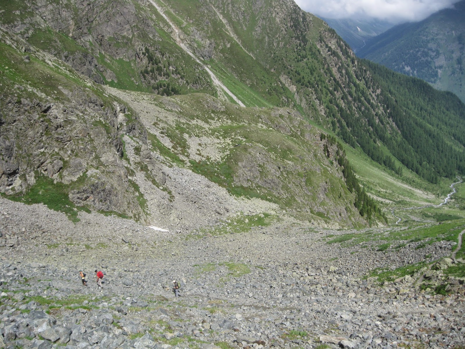
The trail keeps climbing regardless, over a series of barren scree piles. It eventually levels out, the valley walls fall away, bringing me into full-on bright sunshine as I stride along the brook, now right alongside the trail. The air is warm, the wind light, the sky bright blue.
Several of these photos, if enlarged, show the tiny figures of the hikers ahead of me, which provide a sense of scale.
We're there. All around me, the landscape looks like the most barren part of the Scottish Highlands, or perhaps New Hampshire's Presidential range above treeline, but surrounded by dramatic rocky peaks that look like they're from a rendering of Middle Earth. Snowdrifts persist in shady places, but the blamming sunshine lights up the rocky peaks like they're on a movie set. Everything seems to sparkle.
Why don't I let the landscape itself do the talking?
Above is where I came from...
...and this is what lies ahead.
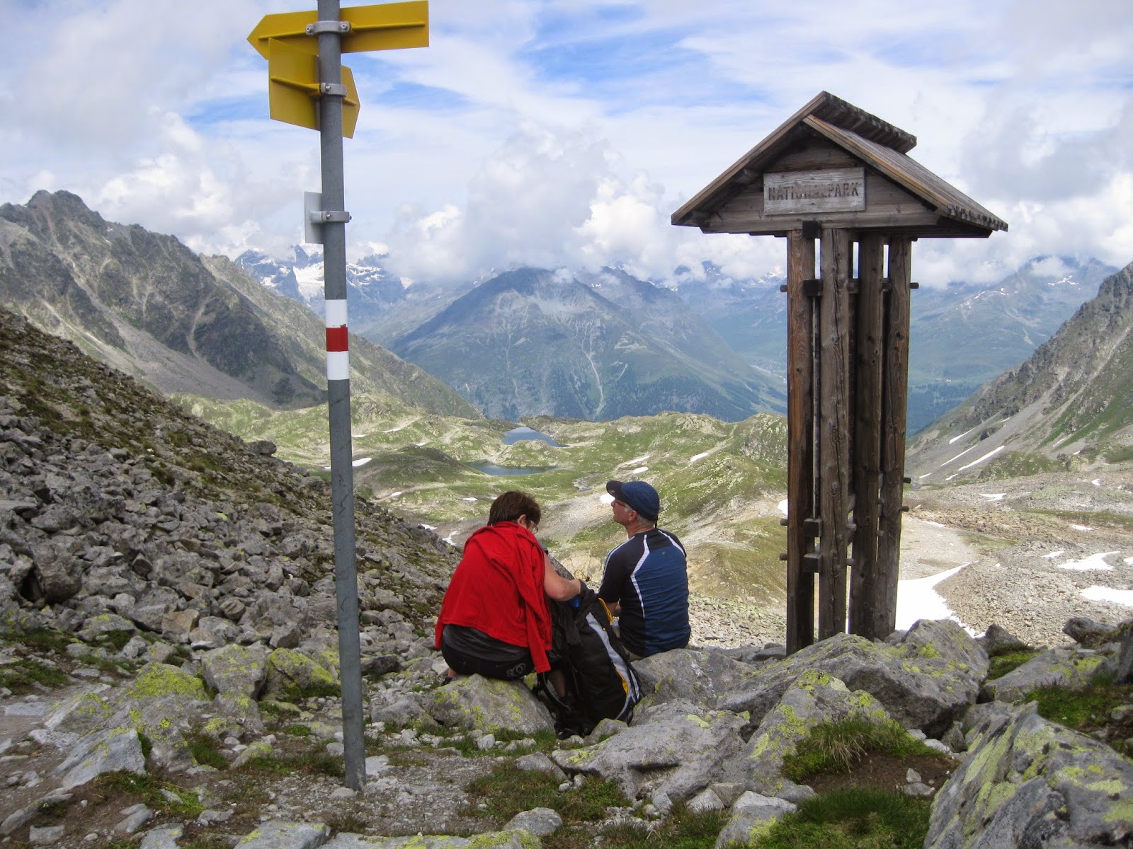
I rock-hop across the brook, then arrive at a sheltered signpost that looks like a bus stop in the middle of nowhere. It marks the official boundary of the Swiss National Park, which the trail now crosses into. A couple that I've been slowly gaining on depart just as I arrive.
Some color is still present, but not for much longer.
With them leading the way, the trail meanders through a treeless alpine moonscape that would surely be forbidding if it weren't so open and well lit, and if the weather weren't so warm and welcoming. As it is, I feel almost giddy. It might be the thinning air: we're already above 8,000 feet, and heading higher.
We follow the course of the burbling stream, then veer to the right and up to reach the official Lake Macun plateau stop: a stretch on the alien shore of a perfectly still alpine tarn that I recognize as the classic Crayola color of
blue green.
It's exactly 11:30 a.m. A signpost, with typical Swiss precision, says it's 4¼ hours to the Zernez train station.
The couple ahead of me had already found a spot on one side of the pond, named "Lai d'Immez" in the native Graubunden dialect of this part of Switzerland. (They're in the second photo above.) They seem to want to be on their own, so I stand away and embark on a 360-degree series of shots. These were later stitched into a single wrap-around panorama by Andrew Mason, a talented colleague at work. Click on the image to see it large:
I also snap this very limited self-portrait while taking off my boots and changing my socks.
The bump is where I broke my big toe years ago. There, now you know everything.
And then it was over a small wooden footbridge and up, up, up. Though the air was mild and the sky above was still blue, a gray and white overcast continued to boil in the east. Time was now a factor: if I was going to get socked in by clouds or rain on above treeline, I had hoped to get up and over the ridge (and the day's high point) that I still had in front of me.
I begin to encounter people coming the other way, off the ridge and headed toward Lavin, where I started. Most are dressed for colder weather than me, it seems, but they say the ridge is fine.
The trail is now up-and-down as it traverses the rocky plateau. Surrounded by barren peaks on all sides, and with none of the green lower valleys in sight, I really have the sense of being somewhere other than Earth. The Planet Macun, perhaps. After awhile, all color vanishes. I was now in the black-and-white (but mostly gray) world of rocks and gravel and shady spots that sheltered snowdrifts that survive in late July.
In that last photo, you can just barely see the little "T" on the ridge.
After crossing several deep snowdrifts, the trail begins a grinding final ascent straight up a steep embankment of loose rock. Way, way up above, sticking up from the ridge top, I can see a little "T" silhouetted against the overcast. If that
was the ridge, then that was another signpost, probably marking the trail's exit from the national park. (At this point, I find myself kinda hoping it's the top of a chairlift that I can ride down.)
A view directly up the final climb.
With the thinner air at this altitude, each step takes all my concentration and quite a bit of effort. Plus, I had just arrived from the U.S. two days ago, making jet lag was a factor as well. So I stop frequently, to the point where I'm taking only a handful of steps before having to rest for at least a moment.
Here's the part I expected would come: when I ask myself what the hell am I doing here? Of course, I had no good answer. For now, my whole world was focused on getting to that "T" up above, and then coping with whatever challenge would follow.
The final push seems to take forever, but when I finally reach the "T," the world opens up. It
is the ridge, and the "T"
is a sheltered sign marking the national park boundary. And all around me, the earth drops away: behind me down to the rocky plateau I just crossed, and ahead into deep green valleys far, far below, and then snowcapped peaks to the horizon.
It feels like I'm looking out the window of an airplane. It feels like I'm flying. One word comes to mind:
vertiginous.
We're at a place called Fuorcletta di Barcli. It's 9,120 feet above sea level, and a good solid
one mile above the valley floor below. The clouds have withdrawn, the sun is shining, and I feel like I can see forever. And I now have a good answer as to what the hell I'm doing here.
I drink some salty water, and make small talk with a middle-aged couple while holding back the urge to belch. They came up from Lavin, and that's where they're heading back to now. Really?
"Yes," says the man. "To go further, it is much too scary for me."
And yes, I'm not done yet. To continue requires one to go higher, up and along the narrow ridge crest for about a quarter-mile, finally topping out at 9,660 feet at a summit called Fuorcla Baselgia.
The trail is no longer a trail, but a series of rock scrambles over a narrow and completely exposed ridge. A sudden gust of wind could turn me into a human kite!
But a large family is making its way down towards us as we speak. How scary could it be?
There's virtually no wind right now. The rain is at bay. The rocks are dry. The worst thing that could happen, I think, is that I could trip or get a sunburn.
So up I climb. As the altitude increases, packed snow persists right up the lip of the ridge's shady side, sometimes forming a shelf as high as my shoulder.
It takes a half-hour, but I finally reach the high point, which I have to myself. No one else is around.
And I have one of those moments where I can't believe I'm actually standing where I am, on perhaps one of the five days of the entire year where the conditions are like this: warm, dry, calm. Pleasant, even! Remember, this is a totally exposed ridge studded with avalanche barriers high above the town of Zernez. Blizzard conditions probably prevail here nine months out of the year.
There's Zernez down there, where I have a train to catch.
At the same time, I am listening to the part of me saying:
You're hiking alone in a strange country, and this part of the journey is where you're most vulnerable. I mean, I'm standing there in shorts and a t-shirt. Sir Edmund Hillary didn't relax at the top of Everest. Neil Armstrong didn't dawdle on the lunar surface.
You know, it kinda does look like Mount Everest or the the lunar surface up here. The last pic is of the actual summit of Mount Baselgia: self-portrait of me and my bag, excluding me.
In other words: take in the view, but get down while the getting's good. Which is what I did.
And therein lay the seeds of my coming misadventure. Once I began descending, I might have been going a little too fast. Because of that, more than ever I was watching where my feet were landing, as the trail was
extremely steep and full of loose dirt and gravel.
So it was with a slight sense of alarm that I looked up and could
not find any evidence of a trail ahead of me. No marker. No red-and-white blaze painted on a rock. Nothing.
A trail
seemed to continue down further, but the slope around me was full of worn and washed out sections that might (or might not) be a path.
Unwilling to drag my aching feet and legs back up the steep grade and crumbling turf, I pressed on, gradually realizing that yes, I was not on any kind of trail at all.
In fact, I was in the wrong valley. Far below me was not Zernez, but—well, nothing. Steep open slopes disappeared into what looked like trackless wilderness.
So what to do? Climbing back up from whence I came seemed unsafe and dangerous. And I knew, from dead reckoning and a map I had, that the trail (and the valley to Zernez with the avalanche barriers) was somewhere to the right of me.
So I would go right. But first, I had to go down farther, to an area that looked a little more open and easier to navigate across.
All the while, I'm on a 45-degree slope that's either tufts of grass or crumbling rock. There's nothing below me for maybe a couple thousand feet, so one false step could have serious consequences.
So I take it slow, knowing that if something happens, it will likely be a long time before anyone finds me.
(Please note the lack of pictures of this part of the day's activities, as I was using both hands to hold on for dear life.)
And I make my way down step by step, further postponing my turn to the right as steep ledges persist on that side. I begin to wonder: will I ever get out of this chute?
I finally come across a reasonably safe route that unfortunately leads me straight into a thicket of weird spiked weeds that rise to my chest.
I back out, but decide it's now or never. Unwilling to go any lower, I clamber
above the spiky weeds, using all fours to brace myself on a crumbling shelf with no clear footing. The phrase
deep shit comes to mind, but I make it.
I then cross a field of loose scree at a steep angle. Nothing moves. I feel like I'm playing the old board game "Avalanche."
Just as I'm saying "that went well," I step onto what seems to be a solid tuft of alpine grass. The whole thing gives way, sliding out from under my feet and sending a flurry of rocks and gravel bounding down the slope below. I slide with it, but fall on my ass and grab at a branch to keep from going further.
I stop and listen to the rocks still tumbling down the slope below me. A large one hits something solid and bounds up in the air before rolling down to infinity. I almost
wish there were someone below there that I could yell at, because I've never felt quite this alone.
How far to the trail? Did I go too low?
Over yet another ledge, and then another pile of scree, then along a very steep and uneven grass embankment. I lose my footing again, this time landing on my ass without sliding. Turning onto my stomach to get up, I find myself staring straight into an enormous black hole in the turf. And my right hand is on a pile of freshly dug dirt outside the entrance. There is animal scat in the grass next to me.
So I'm up and out of there before I have time to think what comes next.
And what
does come next, to my great relief, is the trail, right there basking in the sunlight. Yes!
I remember it was Winston Churchill who was quoted as saying there is no more exhilarating feeling than being shot at and missed. Back on the trail to Zernez, I kinda know what he meant.
The trail now zigzags among the avalanche barriers on the open slopes high above Zernez.
These look small, like little fences, from down below. Close-up, they're massive steel structures—anchored in concrete and as big a row of two-story houses. Dozens are set up at strategic locations to keep the town from being wiped out.
The trail switchbacks among these curious structures, and in some cases directly through them. And I was surprised to find that on warm afternoons, they produce noise!
Really—the heat of the sun makes the metal expand, causing a series of popping sounds at the time I happened to pass through.
Multiply this over several dozen structures, and it sounds like a popcorn machine. I found myself wondering what movies were playing in Zernez.
With the sun still blasting away (no clouds at all now), it takes awhile to reach treeline and its promises of shade.
But treeline also finds the trail morphing into a maintained dirt road that offers no less than an on-call taxi service down to Zernez, which a sign said was still two hours away on foot.
I'm tempted to call, but that would be cheating. Sore feet or not, my plan was to hoof it all the way.
But the trail now follows the road, which makes absurdly leisurely loops through the forest as it winds its way down the slope. I think it adds at least an hour to the hike! And it doesn't help to have to occasionally get out of the way of the "taxi service" (actually a van) plying its way up and down the road.
I was never so glad to find the trail finally breaking off from the road and heading straight down to Zernez. Still, the last part of the hike seemed to take forever—I'd walk for a half-hour, and be no closer to Zernez than before.
Finally, at about 5 p.m., I marched through a field and into the courtyard of Zernez's Catholic Church. After skirting the cemetery (how poetically appropriate), I was now on the tidy town's sidewalks and crosswalks. The rest of my journey I would complete as planned: by
train.
Tramping up to the Lake Macun plateau represents the limit of intense day hikes—at least for me. So I think I really lucked out in being able to make this journey.
Consider: The weather held for the entire day. (It would turn out to be the
only day of our stay that it didn't rain.) Conditions way up on the ridge were superb. The salty mineral water didn't taste great, but probably aided in hydration.
And I didn't kill myself.