My all-weather map of Delaware. Note state's name spelled wrong.
Okay, it's been awhile so figured time for an update.
Amazing but true: I've kept up the one-per-month pace in my quest to run a minimum of 10K in all 50 states.
Just yesterday (Thursday, June 16), it was Delaware. In May, it was Nevada. In April, Massachusetts. The last day of March found me in unseasonably mild rural Rhode Island, while February brought me to Central City, Nebraska, which I discovered is anything but central.
So I'm now up to a total of 24, and running out of close-by states, which means it'll be more challenging to keep the once-a-month pace going.
The only states I have within driving distance are Maine and, sort of, New Jersey.
The remainder will involve at least some kind of trip away from home base to accomplish. Some can be done in one day if I find a cheap air fare.
But right now, I don't have any firm plans until when I go out to California November. That's when I might try to get either Oregon or Washington. Or both. :)
A planned visit to Sioux City, Iowa next February will give me a chance to bag that state and maybe a couple of others in the upper Midwest: South Dakota and Minnesota.
Among states in the "day-trip" category are a stretch in the deep south: South Carolina, Georgia, Tennessee Alabama, Mississippi and Louisiana. With JetBlue and Southwest out of Boston, they're all doable.
Same thing with a few in the Midwest: Indiana, Michigan, and Wisconsin.
Well, if I can somehow keep up a pace of one state per month, that means I'll be finished by...July 2018!
That's not allowing for recovery from knee surgery I'm sure I'll need at some point.
And as for Delaware: Dover is hands-down the flattest place I've ever run in. For the entire route, the biggest gains (or losse) in altitude were when I hopped on and off a curb!
I'll give the place high marks for sidewalks, though. Of the entire 6.6-mile course, which included some stretches of road far out in the suburbs, only one short section was without some kind of pedestrian way.
Lots of bike paths as well. Wish my own area of Manchester, N.H. and its surrounding suburbs could enjoy amenities like this.
In other news:
• Summited Mount Moosilauke with a small party on Saturday, June 11. Didn't add to my total of 4,000-footers, which still stands at 31. Still, it was enough to get me back on the trail.
A busy calendar, alas, means there aren't too many opportunities in the near future to conquer any more of the 48 peaks on the list.
A new wrinkle is our youngest dog, Inca. She likes to get out and did well on Mount Moosilauke, save for not appreciating rain on the way down.
For her, Mount Moosilauke was #6, so it's time to get moving if she's going to have a chance to complete the whole roster.
Alas, our older dog, Zahnna, is now too infirm to haul herself up (and down) a White Mountain summit. As a 13-year-old German Shepherd, she now has trouble with household stairs, so her total of peaks will have to stand at 31—the same as me.
• Haven't yet run in any official road races this year. Again, mostly a function of time and organization. I have these fantasies of getting up early on the weekends and hauling myself out to New Hampshire communities I've yet to run in. Ha!
But will make it a priority to make some progress in this area. Same with longer bike rides.
Friday, June 17, 2016
Wednesday, February 3, 2016
Bagging nearby Vermont (#19) in mid-winter
Bennington's picturesque train depot during greener months.
A mild winter (so far) recently gave me an opening to add to the "Running in All 50 States" project. So I took it!
The opening came on Sunday, Jan. 31, while driving back to New Hampshire from a silent film accompaniment performance in upstate New York.
As I followed Route 67 into Bennington, Vt., it was overcast but mild (above 40 degrees) and getting milder.
It being the final day of January, it was my last chance to get in a long run in a new state, thus extending my streak of consecutive months to a grand total of two.
The trouble was that time was running short. I was due in Wilton, N.H. (about two hours away) for a performance at 4:30 p.m. that very afternoon.
And as I pulled into Bennington, it was already 11:30 a.m.
Some quick in-my-head math convinced me I could still pull off a long run, although there was precious margin for error.
So I sat there in North Bennington and used Google Maps to eyeball a loop route out to Shaftsbury (following the old Rutland Railroad's main line) then down 7A into Bennington, then cutting back through local roads and around the Bennington College campus to back where I started.
The minimum distance for these state runs is 10K, or 6.2 miles. Just to be sure, I quickly drove the planned route, and was surprised to find it added up to 8.0 miles.
Too long! At my pace, I wouldn't finish in time to make it comfortably over to Wilton.
So, looking at the map, I quickly altered the end of the route to tighten the loop and shave off enough distance to shorten the run, but not below 6.2 miles.
Because then it wouldn't count!
With no time to drive this revised route and check the distance, I decided it was time to just do it.
I had dressed for cooler weather, but it was in the mid-40s. So I wound up bare-legged, with only black shorts and my lime green wicking moisture T-shirt. In January in Vermont!
But I really lucked out, not just in weather, but in location. The valley floor in this part of Vermont is studded with village centers and picturesque homes and even a real working railroad line!
So off I went, with North Bennington Village my starting point. Time was 11:47 a.m.
First I crossed over the railroad line while gawking at Bennington's handsome Victorian passenger depot. The depot sits unused but ready to host Amtrak trains from Burlington to NYC in the near future. The clock on the cupola is working and We'll see.
I then quickly found myself in open country, with the road paralleling the rail line in classic New England fashion.
After about two miles, I hit Route 7A in Shaftsbury, where I turned south. The rail line ducked under the road and curved out of sight on its way up to Rutland.
This was the busiest stretch of roadway, and the hilliest. But amazingly, parts of it had sidewalks! So other than dodging snowmelt puddles, it was pretty easy.
I then made the move to shorten the route: turning right on Overlea Road, which would send me right into Bennington College, which I'd skirt to the north on my way back to North Bennington.
The road—really a residential street—was so quiet, I could run in the middle of it for long stretches with no sign of any vehicles.
The grade drifted downwards until it crossed the disused rail spur running south into Bennington—the stub end of what I later learned was called the "Corkscrew Branch" to Albany, N.Y.
Today it dead-ends in Bennington. At the Overlea Road crossing, a clutch of at least two dozen tank cars (that's all I could see) were stored south of the crossing.
I then hauled myself upgrade to make a right on Matteson, which was necessary to have enough distance for this run to count.
My next turn was right on Harlan, but it seemed to be taking a long time to come. Meanwhile, I enjoyed views of the famous Battle of Bennington Monument, which was visible rising from the hills to the south.
Finally, a street on the right. But with a missing street sign! Should I take it or not?
A wrong turn could cost me precious minutes (not to mention foul up my distance), and I had to be in Wilton ready to do a three-hour movie at 4:30 p.m.
Dead reckoning told me to take it, so I did. I slogged upgrade for awhile (This better be the right road!), and was never so relieved to see HARLAN at the next intersection, which was with College Road, my next turn.
College Road skirted the northern boundary of property owned by Bennington College, long famous as the school with the highest tuition in the nation. (I just checked, and that's not true anymore. But still, it's about $50K a year.)
A flat well-paved surface, and complete absence of traffic, inspired me to do a series of "arm lifts" where I reach high, then move my wrists, all while keeping pace running. It really helps break the repetitive running pattern and adds to the aerobic workout.
I was closing in on where I started, but the maps weren't clear about the best road to take, and neither was I.
But a quick turn down a side street put me on Mechanic Street—exactly the right road to take me back to where I started. And it had sidewalks, too!
As I approached my car, I felt not quite sure that I'd completed 6.2 miles. So I kept going up the depot again, and then back, adding perhaps 2/10 of a mile just for insurance.
Stop time: 1:09. But what was the distance?
I drove the route, watching the miles add up. Turning onto Overlea, we still hadn't reached 5, so I began to worry. But we hit 6 while still on College Road, so I knew I'd be okay.
The final tally: 6.6 miles in 1 hour and 22 minutes, or a pace of 12:25 per mile.
I changed my clothes at a gas station along the way.
And yes, I made it to Wilton on time!
A mild winter (so far) recently gave me an opening to add to the "Running in All 50 States" project. So I took it!
The opening came on Sunday, Jan. 31, while driving back to New Hampshire from a silent film accompaniment performance in upstate New York.
As I followed Route 67 into Bennington, Vt., it was overcast but mild (above 40 degrees) and getting milder.
It being the final day of January, it was my last chance to get in a long run in a new state, thus extending my streak of consecutive months to a grand total of two.
The trouble was that time was running short. I was due in Wilton, N.H. (about two hours away) for a performance at 4:30 p.m. that very afternoon.
And as I pulled into Bennington, it was already 11:30 a.m.
Some quick in-my-head math convinced me I could still pull off a long run, although there was precious margin for error.
So I sat there in North Bennington and used Google Maps to eyeball a loop route out to Shaftsbury (following the old Rutland Railroad's main line) then down 7A into Bennington, then cutting back through local roads and around the Bennington College campus to back where I started.
The minimum distance for these state runs is 10K, or 6.2 miles. Just to be sure, I quickly drove the planned route, and was surprised to find it added up to 8.0 miles.
Too long! At my pace, I wouldn't finish in time to make it comfortably over to Wilton.
So, looking at the map, I quickly altered the end of the route to tighten the loop and shave off enough distance to shorten the run, but not below 6.2 miles.
Because then it wouldn't count!
With no time to drive this revised route and check the distance, I decided it was time to just do it.
I had dressed for cooler weather, but it was in the mid-40s. So I wound up bare-legged, with only black shorts and my lime green wicking moisture T-shirt. In January in Vermont!
But I really lucked out, not just in weather, but in location. The valley floor in this part of Vermont is studded with village centers and picturesque homes and even a real working railroad line!
So off I went, with North Bennington Village my starting point. Time was 11:47 a.m.
First I crossed over the railroad line while gawking at Bennington's handsome Victorian passenger depot. The depot sits unused but ready to host Amtrak trains from Burlington to NYC in the near future. The clock on the cupola is working and We'll see.
I then quickly found myself in open country, with the road paralleling the rail line in classic New England fashion.
After about two miles, I hit Route 7A in Shaftsbury, where I turned south. The rail line ducked under the road and curved out of sight on its way up to Rutland.
This was the busiest stretch of roadway, and the hilliest. But amazingly, parts of it had sidewalks! So other than dodging snowmelt puddles, it was pretty easy.
I then made the move to shorten the route: turning right on Overlea Road, which would send me right into Bennington College, which I'd skirt to the north on my way back to North Bennington.
The road—really a residential street—was so quiet, I could run in the middle of it for long stretches with no sign of any vehicles.
The grade drifted downwards until it crossed the disused rail spur running south into Bennington—the stub end of what I later learned was called the "Corkscrew Branch" to Albany, N.Y.
Today it dead-ends in Bennington. At the Overlea Road crossing, a clutch of at least two dozen tank cars (that's all I could see) were stored south of the crossing.
I then hauled myself upgrade to make a right on Matteson, which was necessary to have enough distance for this run to count.
My next turn was right on Harlan, but it seemed to be taking a long time to come. Meanwhile, I enjoyed views of the famous Battle of Bennington Monument, which was visible rising from the hills to the south.
Finally, a street on the right. But with a missing street sign! Should I take it or not?
A wrong turn could cost me precious minutes (not to mention foul up my distance), and I had to be in Wilton ready to do a three-hour movie at 4:30 p.m.
Dead reckoning told me to take it, so I did. I slogged upgrade for awhile (This better be the right road!), and was never so relieved to see HARLAN at the next intersection, which was with College Road, my next turn.
College Road skirted the northern boundary of property owned by Bennington College, long famous as the school with the highest tuition in the nation. (I just checked, and that's not true anymore. But still, it's about $50K a year.)
A flat well-paved surface, and complete absence of traffic, inspired me to do a series of "arm lifts" where I reach high, then move my wrists, all while keeping pace running. It really helps break the repetitive running pattern and adds to the aerobic workout.
I was closing in on where I started, but the maps weren't clear about the best road to take, and neither was I.
But a quick turn down a side street put me on Mechanic Street—exactly the right road to take me back to where I started. And it had sidewalks, too!
As I approached my car, I felt not quite sure that I'd completed 6.2 miles. So I kept going up the depot again, and then back, adding perhaps 2/10 of a mile just for insurance.
Stop time: 1:09. But what was the distance?
I drove the route, watching the miles add up. Turning onto Overlea, we still hadn't reached 5, so I began to worry. But we hit 6 while still on College Road, so I knew I'd be okay.
The final tally: 6.6 miles in 1 hour and 22 minutes, or a pace of 12:25 per mile.
I changed my clothes at a gas station along the way.
And yes, I made it to Wilton on time!
Sunday, December 20, 2015
Adding Pennsylvania (#17) and Kentucky (#18)
Geez, look at those elevation lines to the south of downtown Coraopolis.
Okay, I admit there's been something of a gap in my quest to run a minimum of 10K in each of the 50 states.
With nothing to report since 2013! Really?
But the drought is over, as I chalked up two states in two days during a recent silent film accompaniment road trip from New Hampshire to the Midwest.
The pair are Pennsylvania (#17, on Thursday, Dec. 10) and Kentucky (#18, on Friday, Dec. 11).
I'm not sure what's more amazing: that the December weather allowed for two long pleasant morning runs (in shorts!), or that I was actually able to complete them back-to-back without any injury or problem or really any soreness.
In fact, after each run I felt energized and calm for the rest of the day, a large part of which was filled with driving to the next city.
It reminded me of what it felt like when I was running long distances while a student in Glasgow: early morning runs through unfamiliar territory in cool but not cold weather, followed by a day of classes.
I had originally planned to try for a third state on this trip: Michigan on Saturday, Dec. 12. But this would have required driving two hours each way from where I was staying in Cleveland.
And by then, after spending most of the past three days behind the wheel, I didn't want to give up my one without driving, driving, driving.
Plus, I had completed two long runs in the prior two days. I felt fine, but I knew piling on another long one was courting trouble, and I had miles to go before I slept, if you know what I mean.
The Pennsylvania run was in the town of Coraopolis, a community on the south bank of the Ohio River just downstream from downtown Pittsburgh.
I mapped out what seemed like an easy route to follow, from my Motel 6 at the airport along a Thorn Run Road all the way to the river and downtown Coraopolis, then looping back by Main Street and Maple Street to Coraopolis Heights Road, which ran through a rural area all the way back to the hotel.
Here's Part 1 of the Pennsylvania run, using Dairy Queen as a landmark.
What I didn't count on was the incredibly steep drop down to the river. I expected a downgrade, but not the kind of descent I found myself making from the ridgeline above the Ohio River.
I must have lost at least 700 feet in a very short distance, finally bottoming out on "Fifth Avenue," which would not be mistaken for the New York City thoroughfare of the same name.
What goes down must come up, and I steeled myself (local industry reference!) for the right-hand turn on Main Street that would start taking me back up.
Here's Part 2 of the Pennsylvania run.
Although the small downtown was on a narrow flat plain along the river, the streets to the right of me literally took off up the slope at such a rate that second floor could have a door onto the sidewalk.
Turning onto Main Street, it seemed like it was straight up. Cobblestones were an interesting touch, and block by block I huffed my way back up the ridge.
I then ran into one of those frustrating moments where Google Maps doesn't exactly mirror reality. Main Street went up and up, and so did I, until it reached a dead end!
What? It was supposed to connect with Maple Street Extension, which I believed was the road running far below us. A postman confirmed this, and so I hustled along the edge of a large cemetery (the symbolism was not lost) going down to meet Maple Street Extension, and start the climb back up all over again.
The rest of the run went smoothly. I found myself feeling strong even as Coraopolis Heights Road stretched out before me through rolling countryside, with no sign of the airport for what seemed like a very long time.
End result: 6.9 miles in 1 hour, 31 minutes, for a pace of 13:12. I'll take it, especially considering those long upgrades.
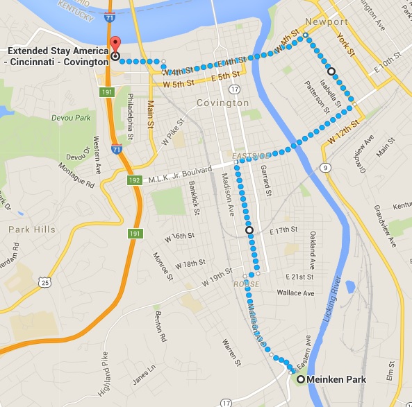
The next morning found me in Covington, Kentucky, the urban community just across the Ohio River from downtown Cincinnati. I plotted a looping route that would take me across the Licking River and back, assuming the bridges had pedestrian crossings.
Weather was the same as the day before: cool and damp, with just the hint of a spritz of rain in the air.
The route first took me across the Licking River into Newport, then back into Covington.
The first bridge did indeed accommodate pedestrians, and I soon found myself in a somewhat down-at-the-heel part of Newport, a place where the Pabst Blue Ribbon people still have a lock on all tavern promotional signs.
But still, the older housing stock had a lot of character, even if some of the brick buildings have been painted in alarming colors.
I then huffed my way back across another bridge and into Covington, where I went through some pretty spectacular neighborhoods, especially the Warren Avenue area.
After reacehing Meinken Park, I headed back, mostly along Madison Avenue almost the whole way back to the hotel.
Taking the direct route back to the hotel, for a total of 8 miles.
End result: 8.0 miles in 1 hour, 45 minutes, for a pace of 13:07. Not bad considering what I'd run the day before.
So I felt pretty good after what for me were two long back-to-back runs.
Back in New Hampshire, the weather continues unseasonably mild even as I write this. So perhaps I might get one more nearby state before the year ends. We'll see.
Okay, I admit there's been something of a gap in my quest to run a minimum of 10K in each of the 50 states.
With nothing to report since 2013! Really?
But the drought is over, as I chalked up two states in two days during a recent silent film accompaniment road trip from New Hampshire to the Midwest.
The pair are Pennsylvania (#17, on Thursday, Dec. 10) and Kentucky (#18, on Friday, Dec. 11).
I'm not sure what's more amazing: that the December weather allowed for two long pleasant morning runs (in shorts!), or that I was actually able to complete them back-to-back without any injury or problem or really any soreness.
In fact, after each run I felt energized and calm for the rest of the day, a large part of which was filled with driving to the next city.
It reminded me of what it felt like when I was running long distances while a student in Glasgow: early morning runs through unfamiliar territory in cool but not cold weather, followed by a day of classes.
I had originally planned to try for a third state on this trip: Michigan on Saturday, Dec. 12. But this would have required driving two hours each way from where I was staying in Cleveland.
And by then, after spending most of the past three days behind the wheel, I didn't want to give up my one without driving, driving, driving.
Plus, I had completed two long runs in the prior two days. I felt fine, but I knew piling on another long one was courting trouble, and I had miles to go before I slept, if you know what I mean.
The Pennsylvania run was in the town of Coraopolis, a community on the south bank of the Ohio River just downstream from downtown Pittsburgh.
I mapped out what seemed like an easy route to follow, from my Motel 6 at the airport along a Thorn Run Road all the way to the river and downtown Coraopolis, then looping back by Main Street and Maple Street to Coraopolis Heights Road, which ran through a rural area all the way back to the hotel.
Here's Part 1 of the Pennsylvania run, using Dairy Queen as a landmark.
What I didn't count on was the incredibly steep drop down to the river. I expected a downgrade, but not the kind of descent I found myself making from the ridgeline above the Ohio River.
I must have lost at least 700 feet in a very short distance, finally bottoming out on "Fifth Avenue," which would not be mistaken for the New York City thoroughfare of the same name.
What goes down must come up, and I steeled myself (local industry reference!) for the right-hand turn on Main Street that would start taking me back up.
Here's Part 2 of the Pennsylvania run.
Although the small downtown was on a narrow flat plain along the river, the streets to the right of me literally took off up the slope at such a rate that second floor could have a door onto the sidewalk.
Turning onto Main Street, it seemed like it was straight up. Cobblestones were an interesting touch, and block by block I huffed my way back up the ridge.
I then ran into one of those frustrating moments where Google Maps doesn't exactly mirror reality. Main Street went up and up, and so did I, until it reached a dead end!
What? It was supposed to connect with Maple Street Extension, which I believed was the road running far below us. A postman confirmed this, and so I hustled along the edge of a large cemetery (the symbolism was not lost) going down to meet Maple Street Extension, and start the climb back up all over again.
The rest of the run went smoothly. I found myself feeling strong even as Coraopolis Heights Road stretched out before me through rolling countryside, with no sign of the airport for what seemed like a very long time.
End result: 6.9 miles in 1 hour, 31 minutes, for a pace of 13:12. I'll take it, especially considering those long upgrades.
The next morning found me in Covington, Kentucky, the urban community just across the Ohio River from downtown Cincinnati. I plotted a looping route that would take me across the Licking River and back, assuming the bridges had pedestrian crossings.
Weather was the same as the day before: cool and damp, with just the hint of a spritz of rain in the air.
The route first took me across the Licking River into Newport, then back into Covington.
The first bridge did indeed accommodate pedestrians, and I soon found myself in a somewhat down-at-the-heel part of Newport, a place where the Pabst Blue Ribbon people still have a lock on all tavern promotional signs.
But still, the older housing stock had a lot of character, even if some of the brick buildings have been painted in alarming colors.
I then huffed my way back across another bridge and into Covington, where I went through some pretty spectacular neighborhoods, especially the Warren Avenue area.
After reacehing Meinken Park, I headed back, mostly along Madison Avenue almost the whole way back to the hotel.
Taking the direct route back to the hotel, for a total of 8 miles.
End result: 8.0 miles in 1 hour, 45 minutes, for a pace of 13:07. Not bad considering what I'd run the day before.
So I felt pretty good after what for me were two long back-to-back runs.
Back in New Hampshire, the weather continues unseasonably mild even as I write this. So perhaps I might get one more nearby state before the year ends. We'll see.
Labels:
Coraopolis,
Covington,
Jeff Rapsis,
Kentucky,
Newport,
Pennsylvania
Sunday, December 6, 2015
Bagging two more New Hampshire towns:
Shelburne (#142) and Gorham (#143)
My turn-around point in Shelburne was this spot, exactly 1.6 miles from where I parked the car at the 27.0 mile marker. Late afternoon in December = looooong shadows.
I never thought I'd go running north of Mount Washington in December—in shorts!
But a spell of unseasonably mild weather in our part of the world allowed me to bag two towns "north of the notches," as they say: rural Shelburne and comparatively cosmopolitan Gorham. And I didn't have to bundle up.
The date: Saturday, Dec. 5. The occasion: on my way to an annual silent film screening in the even-further north community of Dixfield, Maine. The goal: to run a minimum of 5K in at least a couple of towns that I doubt will ever hold an official road race.
I don't often get to run in towns this far north. But in planning this gig, I figured that on my way it might be possible to fit in a run among the enormous snowbanks usually in place by now.
Well, Mother Nature had other plans. The higher summits of the surrounding White Mountains are indeed white, but winter hasn't quite reached the valleys just.
Thus I found myself pulling off Route 2 at the Gorham / Shelburne line onto a grassy patch that made for a perfect parking spot.
As it became clear that the weather would be unseasonably nice, I actually had plans to bag four towns. Before Gorham / Shelburne, I had hoped to do a similar two-town run in Jefferson and Randolph, through which Route 2 also runs.
But coming up through Franconia Notch, I noticed a light coating of snow on the shoulder. And heading further through Twin Mountain, I watched as the temperature dropped below 40 degrees. Anything lower requires extra gear, which I didn't bring.
So I wasn't sure about the Jefferson / Randolph stretch, and then ultimately bagged it because that section of the road is narrow, with very little shoulder, and has a lot of steep ups and downs. That, plus the slushy roadside snow and the at-times heavy traffic, made me push on to Gorham / Shelburne.
It turned out to be the right decision. They're at a lower elevation, so the temp had recovered to the mid-forties by the time I pulled in. Plus, the road follows the Androscoggin River, which at this point flows along a flat stretch of valley. And Route 2 is in pretty good shape in these parts, too.
After measuring off 1.6 miles in each direction, I returned to the town line and began the Shelburne stretch at 3:25 p.m.
A long straightaway and then some up-and-down curves took me through some of the dense groves of birch trees for which Shelburne is known. Fun fact: Shelburne's population was 480 in 1859, but only 372 now. So it's one of those upcountry towns that went into decline after the Civil War and still haven't recovered.
I came back to the car at 4:03 p.m. meaning 38 minutes to do 3.2 miles. Nothing to brag about there.
Heading into Gorham for the second part of the run, it was starting to get dark in the valley even though some of the peaks high above us were still catching the light. The wind picked up a bit, but running in shorts still felt fine.
Talk about scenery! The rocky, snow-capped summit of Mount Madison, the nearest Presidential Range peak and rising high above us to the south, looked more like the Matterhorn than it deserved to.
After the rural emptiness of Shelburne, the town center of Gorham seemed like Midtown Manhattan. Stores, restaurants—even sidewalks! (The town's population is about 3,000.)
After my turn-around point, I was headed east-bound, meaning I could better see the day's fading light still kissing the upper reaches of ridges hemming us in. The snow had probably melted a bit and was now refreezing, making the higher spots look like they were lightly dusted with powdered sugar. (Can you tell I was hungry?)
Funny: in Gorham I passed signed promoting the town's 5K run on Thanksgiving. Ooops, missed it!
Reached the car at 4:43 p.m., meaning about 40 minutes for the final 3.2 miles. By then it was completely dark, but the temperature had dropped just a bit: to 41 degrees.
And so I had just enough time to drive up the street to the town's Subway (housed in a former bank branch office), where I changed into my performing clothes and got a sandwich.
Next up: this coming week I'm on a road trip to Ohio and Toronto, Canada, and so have an opportunity to claim as many as three new states in my quest to run at least 10K in all 50.
Stay tuned!
I never thought I'd go running north of Mount Washington in December—in shorts!
But a spell of unseasonably mild weather in our part of the world allowed me to bag two towns "north of the notches," as they say: rural Shelburne and comparatively cosmopolitan Gorham. And I didn't have to bundle up.
The date: Saturday, Dec. 5. The occasion: on my way to an annual silent film screening in the even-further north community of Dixfield, Maine. The goal: to run a minimum of 5K in at least a couple of towns that I doubt will ever hold an official road race.
I don't often get to run in towns this far north. But in planning this gig, I figured that on my way it might be possible to fit in a run among the enormous snowbanks usually in place by now.
Well, Mother Nature had other plans. The higher summits of the surrounding White Mountains are indeed white, but winter hasn't quite reached the valleys just.
Thus I found myself pulling off Route 2 at the Gorham / Shelburne line onto a grassy patch that made for a perfect parking spot.
As it became clear that the weather would be unseasonably nice, I actually had plans to bag four towns. Before Gorham / Shelburne, I had hoped to do a similar two-town run in Jefferson and Randolph, through which Route 2 also runs.
But coming up through Franconia Notch, I noticed a light coating of snow on the shoulder. And heading further through Twin Mountain, I watched as the temperature dropped below 40 degrees. Anything lower requires extra gear, which I didn't bring.
So I wasn't sure about the Jefferson / Randolph stretch, and then ultimately bagged it because that section of the road is narrow, with very little shoulder, and has a lot of steep ups and downs. That, plus the slushy roadside snow and the at-times heavy traffic, made me push on to Gorham / Shelburne.
It turned out to be the right decision. They're at a lower elevation, so the temp had recovered to the mid-forties by the time I pulled in. Plus, the road follows the Androscoggin River, which at this point flows along a flat stretch of valley. And Route 2 is in pretty good shape in these parts, too.
After measuring off 1.6 miles in each direction, I returned to the town line and began the Shelburne stretch at 3:25 p.m.
A long straightaway and then some up-and-down curves took me through some of the dense groves of birch trees for which Shelburne is known. Fun fact: Shelburne's population was 480 in 1859, but only 372 now. So it's one of those upcountry towns that went into decline after the Civil War and still haven't recovered.
I came back to the car at 4:03 p.m. meaning 38 minutes to do 3.2 miles. Nothing to brag about there.
Heading into Gorham for the second part of the run, it was starting to get dark in the valley even though some of the peaks high above us were still catching the light. The wind picked up a bit, but running in shorts still felt fine.
Talk about scenery! The rocky, snow-capped summit of Mount Madison, the nearest Presidential Range peak and rising high above us to the south, looked more like the Matterhorn than it deserved to.
After the rural emptiness of Shelburne, the town center of Gorham seemed like Midtown Manhattan. Stores, restaurants—even sidewalks! (The town's population is about 3,000.)
After my turn-around point, I was headed east-bound, meaning I could better see the day's fading light still kissing the upper reaches of ridges hemming us in. The snow had probably melted a bit and was now refreezing, making the higher spots look like they were lightly dusted with powdered sugar. (Can you tell I was hungry?)
Funny: in Gorham I passed signed promoting the town's 5K run on Thanksgiving. Ooops, missed it!
Reached the car at 4:43 p.m., meaning about 40 minutes for the final 3.2 miles. By then it was completely dark, but the temperature had dropped just a bit: to 41 degrees.
And so I had just enough time to drive up the street to the town's Subway (housed in a former bank branch office), where I changed into my performing clothes and got a sandwich.
Next up: this coming week I'm on a road trip to Ohio and Toronto, Canada, and so have an opportunity to claim as many as three new states in my quest to run at least 10K in all 50.
Stay tuned!
Labels:
5K,
Gorham,
Jeff Rapsis,
New Hampshire,
running,
Shelburne
Wednesday, November 4, 2015
Another month, another half-marathon!
In the least unflattering photo of several taken during the race, I'm about to cross the finish line.
It was a few days ago now. But this is to note that I ran in and finished the half-marathon version of this year's Manchester (N.H.) City Marathon.
The race, held Sunday, Nov. 1, 2015, attracted 344 entrants for the half-marathon of 13.1 miles, vs. about 200 for the full 26.2-mile marathon.
In a race this long, most of my effort goes into carefully pacing myself so as not to become hobbled prior to finishing.
The Manchester course contains quite a few ups and downs, and I have to be very careful not to overdo it on the downs, as this is where bodily stress accumulates fast.
Also, there's a short section of trail running in Livingston Park, which is beautiful to look at, but can trigger problems as my feet hit the rocky surface. So I take it especially slow during that stretch.
But I did manage to keep stride the whole time, not stopping once. I finished at 2 hours, 43 minutes, and 41 seconds, for an overall pace of 12:29 per mile.
That was good enough for 323rd place out of 344 finishers, which is a victory for me in the sense that avoided coming in dead last.
It was my slowest half-marathon yet, but the silver lining is that afterwards I felt only minimal soreness in my feet, ankles, and legs.
After two half-marathons in the last month, could I be building up my ability to run longer distances?
And could that possibly lead to trying to run a full 26.2-mile marathon one of these days?
Time will tell.
Next up: an attempt to add Nevada to the list of states in which I've run a minimum of 10K.
I was hoping October would allow me to add Vermont, but a flat tire and other misadventures during a swing through the Green Mountain State prevented that from happening.
And also, I find I've been missing races in N.H. towns that I could still use.
Just this past month, 5K races were run in Walpole and Holderness, two towns I've wanted to get for a long time. Grrrrrr.
I used to rely on www.coolrunning.com for race listings, but a recent "upgrade" to the site has rendered the "upcoming events" much harder to use and a lot less comprehensive, apparently.
However, the site still carries results of races, which is how I found out about the ones I missed.
So I'll have to reverse-engineer the process, reviewing results from this year and then searching to see if the race will be run next year.
No one said this was supposed to be easy. But sometimes it's harder to find out about races than actually run in them!
It was a few days ago now. But this is to note that I ran in and finished the half-marathon version of this year's Manchester (N.H.) City Marathon.
The race, held Sunday, Nov. 1, 2015, attracted 344 entrants for the half-marathon of 13.1 miles, vs. about 200 for the full 26.2-mile marathon.
In a race this long, most of my effort goes into carefully pacing myself so as not to become hobbled prior to finishing.
The Manchester course contains quite a few ups and downs, and I have to be very careful not to overdo it on the downs, as this is where bodily stress accumulates fast.
Also, there's a short section of trail running in Livingston Park, which is beautiful to look at, but can trigger problems as my feet hit the rocky surface. So I take it especially slow during that stretch.
But I did manage to keep stride the whole time, not stopping once. I finished at 2 hours, 43 minutes, and 41 seconds, for an overall pace of 12:29 per mile.
That was good enough for 323rd place out of 344 finishers, which is a victory for me in the sense that avoided coming in dead last.
It was my slowest half-marathon yet, but the silver lining is that afterwards I felt only minimal soreness in my feet, ankles, and legs.
After two half-marathons in the last month, could I be building up my ability to run longer distances?
And could that possibly lead to trying to run a full 26.2-mile marathon one of these days?
Time will tell.
Next up: an attempt to add Nevada to the list of states in which I've run a minimum of 10K.
I was hoping October would allow me to add Vermont, but a flat tire and other misadventures during a swing through the Green Mountain State prevented that from happening.
And also, I find I've been missing races in N.H. towns that I could still use.
Just this past month, 5K races were run in Walpole and Holderness, two towns I've wanted to get for a long time. Grrrrrr.
I used to rely on www.coolrunning.com for race listings, but a recent "upgrade" to the site has rendered the "upcoming events" much harder to use and a lot less comprehensive, apparently.
However, the site still carries results of races, which is how I found out about the ones I missed.
So I'll have to reverse-engineer the process, reviewing results from this year and then searching to see if the race will be run next year.
No one said this was supposed to be easy. But sometimes it's harder to find out about races than actually run in them!
Tuesday, October 20, 2015
Bagging two Connecticut River valley towns:
Orford (#141) and Lyme (#142), plus a flat tire
A swing through the Connecticut River Valley this past weekend led to the latest trophies in my quest to run at least 5K in every New Hampshire city, town, or unincorporated place.
On Saturday, Oct. 17, I bagged the small rural communities of Orford and Lyme, making them #141 and #142, respectively.
It's a beautiful part of the state, and the run took place along a lonely stretch of Route 10 that saw very little traffic.
To get there, I came up I-91 from White River Junction, Vt., crossing back over to New Hampshire via the Samuel Morey Memorial Bridge. It's a classic green steel arch span built in 1937-38 after the great floods of 1936 washed away its wooden predecessor.
The bridge was recently rehabbed and looks brand new. Here's a photo from the Valley News, a daily paper that circulates in the area:
I assume unicycles aren't commonly seen around here.
My aim was the Orford/Lyme town line, from which I'd measure off 1.6 miles in either direction. Conveniently, the spot is served by a school bus turn-around, allowing for easy parking.
Here's a view north on Route 10 into Orford.
And here's a view showing the other direction, south into Lyme.
A cold front was pushing its way in from the west, making for cool and changeable conditions. Temps were in the mid-40s, with occasional breaks of sun balancing off chilly winds. Still shorts weather, but just barely.
I started at 1:20 p.m., heading north into Orford, where the highway runs through the relatively rich farmland (for New Hampshire, anyway) of the Upper Connecticut River Valley. My route took me right past a large and active dairying operation, which on the wind smelled like wet leaves being rubbed in my face.
Looking south from the Orford turn-around point.
One big up-and-down took me to my first turn-around point: Tree Farm Road, exactly 1.6 miles from the town line. I touched it and then headed back, ready to smell more "wet leaves."
Traffic was so light, and the shoulder was often so crumbled, that I found myself gravitating into the travel lanes along the long straight-aways, which offered a better surface. Yes, Route 10 is a major state highway, but often the only sound I could hear was of my shoes scuffing the pavement.
While passing into Lyme, I checked the car's dashboard clock: 2 p.m. exactly, or 40 minutes to do maybe 3.4 miles. Pretty slow!
The route into Lyme consisted of a pretty significant downhill stretch followed by a flat road, then a pronounced up-and-down dip as the highway negotiated a swale.
It was this spot where I encountered a deer leaping across the highway in broad daylight as I was measuring off the distance. But all was now quiet as I ran through this area.
Turn-around point was this "Bear Left" sign, which I touched and then turned around.
Facing north, you can see the dip in Route 10 in the distance.
The way back included a nice slog back upthe grade I'd descended earlier. But everything held together as I reached the starting point at 2:40 p.m.—so 40 minutes for the Lyme leg, exactly the same as Orford.
So that allows me to color in two good-sized adjacent communities on my big New Hampshire map: Orford as #141 and Lyme as #142. Even though the weather is changing, I hope to keep the momentum going and bag a few more before the oncoming winter buries us.
Alas, I returned to find my rear driver's side tire nearly flat. The car was still driveable, though, so I rolled slowly until the first air pump, which I found across the river in Fairlee, Vt.
That was enough to get me to Rutland, Vt., where the tire went completely flat. Swapping it out for the "donut" spare required me to unload all my musical gear into the parking lot of a Days Inn, leading to the discovery that my Subaru Forester is missing its jack!
But I was able to borrow one from some leaf-peepers from New Jersey, which allowed me to complete the swap and make it to my silent film gig that night in Brandon, Vt.
The car has All Wheel Drive, so I really didn't want to drive any real distance without matching tires. Luckily, I had arranged to stay in Rutland that might because of a show the next day in Charlestown, N.H.
So on Sunday morning, I was relieved to find that a Tire Warehouse place in Rutland was open. And it took them just a few minutes to find a nice piece of heavy gauge metal wire than had somehow pierced the tire. It was easily patched for $25, saving me the unplanned cost of a full set of new tires.
Alas, this adventure got in the way of plans to run 10K in Rutland that morning, which would have added Vermont to the list of states that I've run in.
But Vermont is close by, and also it was actually snowing on Sunday morning. So both factors figured into the decision to hold off.
On the upside, the morning overcast blew out to reveal an autumn riot of vivid colors in the landscape: blazing foliage on surrounding slopes, topped with brilliant white snow on a few higher peaks, all under a bright blue sky. It was like one of those idealized postcards of New England, but it was real.
The brilliant sun also lit up Jones' Bakery, a place I'd always wondered about. I'd never been in Rutland when it was open, but that's because it's only open on mornings.
A visit found a real throw-back: a local bakery in operation for 93 years, I was told, with everything made from scratch.
So I celebrated my new tire patch with a couple of real donuts: a plain and their version of a Boston Creme. Both were just fantastic, prompting me to get a dozen to bring to work the next day.
Next big adventure: the Manchester (N.H.) Marathon on Sunday, Nov. 1. I'm running the half-sized version. Lots of ups and downs in this one, but still hoping to beat my time of 2:39:38 earlier this month.
On Saturday, Oct. 17, I bagged the small rural communities of Orford and Lyme, making them #141 and #142, respectively.
It's a beautiful part of the state, and the run took place along a lonely stretch of Route 10 that saw very little traffic.
To get there, I came up I-91 from White River Junction, Vt., crossing back over to New Hampshire via the Samuel Morey Memorial Bridge. It's a classic green steel arch span built in 1937-38 after the great floods of 1936 washed away its wooden predecessor.
The bridge was recently rehabbed and looks brand new. Here's a photo from the Valley News, a daily paper that circulates in the area:
I assume unicycles aren't commonly seen around here.
My aim was the Orford/Lyme town line, from which I'd measure off 1.6 miles in either direction. Conveniently, the spot is served by a school bus turn-around, allowing for easy parking.
Here's a view north on Route 10 into Orford.
And here's a view showing the other direction, south into Lyme.
A cold front was pushing its way in from the west, making for cool and changeable conditions. Temps were in the mid-40s, with occasional breaks of sun balancing off chilly winds. Still shorts weather, but just barely.
I started at 1:20 p.m., heading north into Orford, where the highway runs through the relatively rich farmland (for New Hampshire, anyway) of the Upper Connecticut River Valley. My route took me right past a large and active dairying operation, which on the wind smelled like wet leaves being rubbed in my face.
Looking south from the Orford turn-around point.
One big up-and-down took me to my first turn-around point: Tree Farm Road, exactly 1.6 miles from the town line. I touched it and then headed back, ready to smell more "wet leaves."
Traffic was so light, and the shoulder was often so crumbled, that I found myself gravitating into the travel lanes along the long straight-aways, which offered a better surface. Yes, Route 10 is a major state highway, but often the only sound I could hear was of my shoes scuffing the pavement.
While passing into Lyme, I checked the car's dashboard clock: 2 p.m. exactly, or 40 minutes to do maybe 3.4 miles. Pretty slow!
The route into Lyme consisted of a pretty significant downhill stretch followed by a flat road, then a pronounced up-and-down dip as the highway negotiated a swale.
It was this spot where I encountered a deer leaping across the highway in broad daylight as I was measuring off the distance. But all was now quiet as I ran through this area.
Turn-around point was this "Bear Left" sign, which I touched and then turned around.
Facing north, you can see the dip in Route 10 in the distance.
The way back included a nice slog back upthe grade I'd descended earlier. But everything held together as I reached the starting point at 2:40 p.m.—so 40 minutes for the Lyme leg, exactly the same as Orford.
So that allows me to color in two good-sized adjacent communities on my big New Hampshire map: Orford as #141 and Lyme as #142. Even though the weather is changing, I hope to keep the momentum going and bag a few more before the oncoming winter buries us.
Alas, I returned to find my rear driver's side tire nearly flat. The car was still driveable, though, so I rolled slowly until the first air pump, which I found across the river in Fairlee, Vt.
That was enough to get me to Rutland, Vt., where the tire went completely flat. Swapping it out for the "donut" spare required me to unload all my musical gear into the parking lot of a Days Inn, leading to the discovery that my Subaru Forester is missing its jack!
But I was able to borrow one from some leaf-peepers from New Jersey, which allowed me to complete the swap and make it to my silent film gig that night in Brandon, Vt.
The car has All Wheel Drive, so I really didn't want to drive any real distance without matching tires. Luckily, I had arranged to stay in Rutland that might because of a show the next day in Charlestown, N.H.
So on Sunday morning, I was relieved to find that a Tire Warehouse place in Rutland was open. And it took them just a few minutes to find a nice piece of heavy gauge metal wire than had somehow pierced the tire. It was easily patched for $25, saving me the unplanned cost of a full set of new tires.
Alas, this adventure got in the way of plans to run 10K in Rutland that morning, which would have added Vermont to the list of states that I've run in.
But Vermont is close by, and also it was actually snowing on Sunday morning. So both factors figured into the decision to hold off.
On the upside, the morning overcast blew out to reveal an autumn riot of vivid colors in the landscape: blazing foliage on surrounding slopes, topped with brilliant white snow on a few higher peaks, all under a bright blue sky. It was like one of those idealized postcards of New England, but it was real.
The brilliant sun also lit up Jones' Bakery, a place I'd always wondered about. I'd never been in Rutland when it was open, but that's because it's only open on mornings.
A visit found a real throw-back: a local bakery in operation for 93 years, I was told, with everything made from scratch.
So I celebrated my new tire patch with a couple of real donuts: a plain and their version of a Boston Creme. Both were just fantastic, prompting me to get a dozen to bring to work the next day.
Next big adventure: the Manchester (N.H.) Marathon on Sunday, Nov. 1. I'm running the half-sized version. Lots of ups and downs in this one, but still hoping to beat my time of 2:39:38 earlier this month.
Sunday, October 4, 2015
Back in the half-marathon business:
What a difference a single second makes
>A vintage postcard of the route to make up for my lack of photos.
It's been a couple of years since I last ran a half-marathon.
But the drought's over as of yesterday (Saturday, Oct. 3), when I joined in the half-sized version of the New Hampshire Marathon up in the Newfound Lake area of our state.
Time: 2:39:38. Nothing to brag about, but I did achieve my twin goals of:
• Finishing.
• Not being last.
Actually, I placed 199 out of 239 entrants overall, and 15 out of 18 in my age group, which has now ratcheted up to the 50-59 category. Not bad.
I still think road races should group runners by inseam, not age, but that's another issue.
The one unexpected triumph was that for the first time ever, I completed a half-marathon before any of the full marathon entrants.
This is unusual because generally I run at about slightly less than half the pace of an elite runner.
Do the math, and this means that in any race, at least a few full marathon runners will complete the 26.2-mile course before I plod across the finish line after 13.1 miles, or half the distance.
But not yesterday. I came in about 90 seconds before the full marathon winner, Jim Johnson from Madison, N.H., who finished in 2:41:06.
His pace: 6:06 per mile. My pace: 12.11 per mile. If I'd been one second slower per mile, he'd have caught me. How's that for Wide-World-of-Sports-worthy drama?
So for the first time in a looooong while, I got to see a runner finish a race by breaking through a tape. Nice!
Still, I wasn't sure about attempting 13.1 miles because I hadn't entered any races of any kind all summer. And I'd been following nothing like any kind of training regime.
But I have been running with the dogs pretty regularly, doing distances ranging from 3 to 7 miles and without much trouble.
And the New Hampshire Half-Marathon's point-to-point course is mostly downhill. And I'd already paid $60 to register.
And the weather yesterday morning was perfect. So off I went to see how I'd fare.
Home base was Newfound Memorial Middle School in downtown Bristol, N.H., where the full Marathon started and finished. The 26.2-mile course makes a complete loop around Newfound Lake, much of it running right along the shoreline and showcasing classic New Hampshire scenery in every mile.
For the Half-Marathon, runners were taken by school bus way out to the far end of the lake, to a starting line at the half-way point of the full marathon.
We then basically ran the last half of the full race, mostly along the western shore of Newfound Lake and then to the finish line back at the school in downtown Bristol.
A highlight of the course was several miles on West Shore Road, a ridiculously scenic route that hugs Newfound Lake. Sorry, no pictures—although a woman ahead of me for much of the race kept stopping to take shots with her phone. Actually, a company was on the course taking photos, and they'll be available next week.)
An east wind coming off the water was enough to make flags snap in the breeze and nicely balanced the October morning sunshine.
Although much of West Shore Road is lined by lake cottages and condos, there's one stretch where it runs along the base of rocky cliffs where there's no room to build anything.
This was around Mile 7, when runners had spread out enough so that I was pretty much on my own. Traffic was sparse.
So for awhile there, it was just me and the road and the water, and the wind off the lake and the sun on the cliffs, lighting up everything like it was a stage set.
I felt twinges of serious pain only twice. At about the 4-mile mark, the bones of the middle toe of my left foot felt like they were on fire for a short time. This was alarming, coming so early in the race, but I ran it off by modifying my stride and slowing the pace a bit.
The same thing happened at the 8-mile mark, although with the right foot. Once again it faded away, but I had to be mindful of these hotspots.
After the race, I was somewhat sore, but nothing terrible. Very stiff the morning after, but I've been functioning okay. Not too bad for a 13.1-mile exercise in bodily destruction.
One reason the New Hampshire Half-Marathon was on my to-do list is because the course touches a trio of obscure Granite State towns that I haven't yet run in: Groton, Hebron, and Alexandria. (I already got Bristol some time ago.)
So now I can color in those three on my big state map, which is how I keep track of my ongoing quest to run a race (or a minimum of 5K) in every single one of the Granite State's cities, towns, and unincorporated places.
This has been going on since 2001, when I started running again after a long intermission.
I haven't made much progress lately, for two reasons.
First, I haven't been running a lot of races, mostly because of time. It can take pretty much a full day to get out to a race, run it, and then get back home.
And also, I've already run races in pretty much every city or town that hosts them. In New Hampshire, very few "virgin" towns come up on the running calendar for me.
But these three can now be added to the list, bringing the total to something like 135 or so. (I have to check—it's been awhile since I've added to this list.)
I do think that my self-imposed deadline of May 14, 2016 to complete this quest will slip by at this point. I still have about 100 locations to go, and many of them are up north and not exactly easily accessible.
And then I have other quests, which include hiking to the top of all 48 of New Hampshire's 4,000-footers (I'm up to 33) and also running a minimum of 10K in all of the 50 states.
On the "50 states" challenge, I'm up to 16, but plan to add two more this month and then another in November.
At this point in the season, I won't tackle any mountain peaks until next spring, unless I go skiing. But there's still time to bag a few more Granite State communities by running in them before the snow flies.
See you on the roads!
It's been a couple of years since I last ran a half-marathon.
But the drought's over as of yesterday (Saturday, Oct. 3), when I joined in the half-sized version of the New Hampshire Marathon up in the Newfound Lake area of our state.
Time: 2:39:38. Nothing to brag about, but I did achieve my twin goals of:
• Finishing.
• Not being last.
Actually, I placed 199 out of 239 entrants overall, and 15 out of 18 in my age group, which has now ratcheted up to the 50-59 category. Not bad.
I still think road races should group runners by inseam, not age, but that's another issue.
The one unexpected triumph was that for the first time ever, I completed a half-marathon before any of the full marathon entrants.
This is unusual because generally I run at about slightly less than half the pace of an elite runner.
Do the math, and this means that in any race, at least a few full marathon runners will complete the 26.2-mile course before I plod across the finish line after 13.1 miles, or half the distance.
But not yesterday. I came in about 90 seconds before the full marathon winner, Jim Johnson from Madison, N.H., who finished in 2:41:06.
His pace: 6:06 per mile. My pace: 12.11 per mile. If I'd been one second slower per mile, he'd have caught me. How's that for Wide-World-of-Sports-worthy drama?
So for the first time in a looooong while, I got to see a runner finish a race by breaking through a tape. Nice!
Still, I wasn't sure about attempting 13.1 miles because I hadn't entered any races of any kind all summer. And I'd been following nothing like any kind of training regime.
But I have been running with the dogs pretty regularly, doing distances ranging from 3 to 7 miles and without much trouble.
And the New Hampshire Half-Marathon's point-to-point course is mostly downhill. And I'd already paid $60 to register.
And the weather yesterday morning was perfect. So off I went to see how I'd fare.
Home base was Newfound Memorial Middle School in downtown Bristol, N.H., where the full Marathon started and finished. The 26.2-mile course makes a complete loop around Newfound Lake, much of it running right along the shoreline and showcasing classic New Hampshire scenery in every mile.
For the Half-Marathon, runners were taken by school bus way out to the far end of the lake, to a starting line at the half-way point of the full marathon.
We then basically ran the last half of the full race, mostly along the western shore of Newfound Lake and then to the finish line back at the school in downtown Bristol.
A highlight of the course was several miles on West Shore Road, a ridiculously scenic route that hugs Newfound Lake. Sorry, no pictures—although a woman ahead of me for much of the race kept stopping to take shots with her phone. Actually, a company was on the course taking photos, and they'll be available next week.)
An east wind coming off the water was enough to make flags snap in the breeze and nicely balanced the October morning sunshine.
Although much of West Shore Road is lined by lake cottages and condos, there's one stretch where it runs along the base of rocky cliffs where there's no room to build anything.
This was around Mile 7, when runners had spread out enough so that I was pretty much on my own. Traffic was sparse.
So for awhile there, it was just me and the road and the water, and the wind off the lake and the sun on the cliffs, lighting up everything like it was a stage set.
I felt twinges of serious pain only twice. At about the 4-mile mark, the bones of the middle toe of my left foot felt like they were on fire for a short time. This was alarming, coming so early in the race, but I ran it off by modifying my stride and slowing the pace a bit.
The same thing happened at the 8-mile mark, although with the right foot. Once again it faded away, but I had to be mindful of these hotspots.
After the race, I was somewhat sore, but nothing terrible. Very stiff the morning after, but I've been functioning okay. Not too bad for a 13.1-mile exercise in bodily destruction.
One reason the New Hampshire Half-Marathon was on my to-do list is because the course touches a trio of obscure Granite State towns that I haven't yet run in: Groton, Hebron, and Alexandria. (I already got Bristol some time ago.)
So now I can color in those three on my big state map, which is how I keep track of my ongoing quest to run a race (or a minimum of 5K) in every single one of the Granite State's cities, towns, and unincorporated places.
This has been going on since 2001, when I started running again after a long intermission.
I haven't made much progress lately, for two reasons.
First, I haven't been running a lot of races, mostly because of time. It can take pretty much a full day to get out to a race, run it, and then get back home.
And also, I've already run races in pretty much every city or town that hosts them. In New Hampshire, very few "virgin" towns come up on the running calendar for me.
But these three can now be added to the list, bringing the total to something like 135 or so. (I have to check—it's been awhile since I've added to this list.)
I do think that my self-imposed deadline of May 14, 2016 to complete this quest will slip by at this point. I still have about 100 locations to go, and many of them are up north and not exactly easily accessible.
And then I have other quests, which include hiking to the top of all 48 of New Hampshire's 4,000-footers (I'm up to 33) and also running a minimum of 10K in all of the 50 states.
On the "50 states" challenge, I'm up to 16, but plan to add two more this month and then another in November.
At this point in the season, I won't tackle any mountain peaks until next spring, unless I go skiing. But there's still time to bag a few more Granite State communities by running in them before the snow flies.
See you on the roads!
Subscribe to:
Posts (Atom)